That's much better HB. I can see the exact spot where I dumped my motorcycle a couple of years of ago. 
At about the 17 second mark where does the road on the left lead to?


Posted 16 July 2016 - 07:37 PM
That's much better HB. I can see the exact spot where I dumped my motorcycle a couple of years of ago.
At about the 17 second mark where does the road on the left lead to?

Posted 17 July 2016 - 09:01 AM
They are logging up there at :17 mark on left faller signs no entry possible
GET OFF MY LAWN

Posted 17 July 2016 - 10:33 AM
Nice journey HB, thanks for that.

Posted 18 July 2016 - 11:53 AM
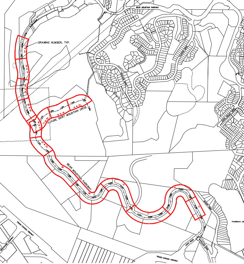
Langford has the tender for the Bear Mountain extension out for bids.
Closes July 28.
The City of Langford is constructing a 3.3km long municipal collector road with associated infrastructure. Infrastructure general includes water, storm, sanitary, hydro, street lighting, as well as significant rock blasting and grading work.
If you're a keener, you can view all 97 drawings through the BC Bid site.
Deepest cut to finish grade I saw was ~10 metres.

Posted 18 July 2016 - 01:14 PM
From the tender document:
Posted 18 July 2016 - 01:40 PM
That part that says future Skirt Mtn drive is already graded and goes up to a larger water reservoir.
It goes to the summit of Skirt Mtn.
The summit of Mini Skirt Mtn is being built on now up on Navigator Rise nice homes with great view on miniskirt
Posted 14 October 2016 - 11:58 AM
That's much better HB. I can see the exact spot where I dumped my motorcycle a couple of years of ago.
At about the 17 second mark where does the road on the left lead to?
Checked it out this morning.
It goes into a clear cut which appears to have been subdivided not sure if its subdivided for commercial or residential.
Edited by HB, 14 October 2016 - 11:58 AM.

Posted 09 April 2018 - 09:05 AM
https://victoria.cit...tuesday-at-7pm/

Posted 09 April 2018 - 03:48 PM
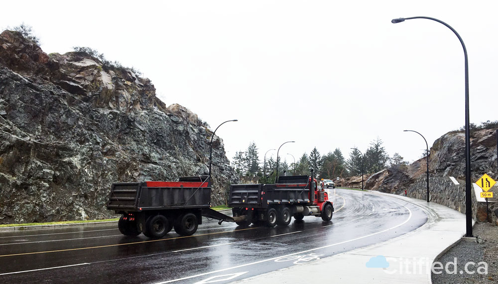
I see in this picture (and others, and having been at that intersection) that there are bikes lanes at least at the start. Do we know if those lanes continue all the way to (or close to) Country Club Way?
If so that will be an interesting juxtaposition with Bear Mountain Parkway from Country Club Way to Millstream Rd, which is quite narrow and ill-suited for passing cyclists.

Posted 09 April 2018 - 09:14 PM
Yes, they extend all the way up to Country Club Way.
Welcome to VV, btw!
Know it all.
Citified.ca is Victoria's most comprehensive research resource for new-build homes and commercial spaces.

Posted 10 April 2018 - 06:09 PM
Colwood

Posted 10 April 2018 - 06:15 PM
Posted 10 April 2018 - 10:01 PM
For healthy alternative transportation people, all y'all sure don't like to be inconvenienced by 20 ft out of the way.
What does "20 ft out of the way" refer to?
Posted 10 April 2018 - 10:10 PM
I rode up on Sunday and the bike lanes stop after the first bend. There is signs of a dedicated trail off to the side but looks a long way off, just gravel.
Well that's a bit of a disappointment. Is the road at least wide enough to accommodate motor vehicles passing bicycles the rest of the way up?
I suppose now that it's open tonight I can go check it out myself. 
Colwood
Posted 11 April 2018 - 05:15 AM

Posted 11 April 2018 - 07:12 AM
Did the property owners and developers ever come through with the $28M they owed Langford for this project?

Posted 11 April 2018 - 07:58 AM
^^Lets see this thread a comment about the trail being a long way off and then another comment on the bridge about how fair out of the way one thing our the other is.
*20 ft away is an exaggeration but definitely not inconvenient l.
jjmac can correct me if I'm wrong, but I believe the "long way off" comment was in reference to the dedicated trail not being done yet, as in, a long way off from being complete.
Posted 11 April 2018 - 10:01 AM
jjmac can correct me if I'm wrong, but I believe the "long way off" comment was in reference to the dedicated trail not being done yet, as in, a long way off from being complete.
That makes sense. I drove over BMP this morning from Leigh Rd to Millstream and although it's open to the public, it's certainly not finished.
As for the non-intuitive directive to ride on the sidewalk, I didn't see it this morning (difficult when driving the other way, even with a passenger rubbernecking for it) but Google Street View from 2014 does show the sign where the sidewalk splits away from the curb shortly before Echo Valley Dr. The More You Know™...
I suspect that crusher trail that parallels BMP on the way up from Leigh Rd may end up being a similar solution as the new road section isn't any wider that the old, so shoulders aren't likely to be a thing.
Looks like it will be a nice climb at any rate. 
Posted 11 April 2018 - 11:00 AM
My mistake! The bicycle lane on pavement does indeed end just beyond McCallum. The rest of the way there is a gravel pedestrian/cycling area up to the resort. The shoulders and non-vehicle portion of the road are not finished yet as DustMagnet says.
Know it all.
Citified.ca is Victoria's most comprehensive research resource for new-build homes and commercial spaces.
Posted 11 April 2018 - 11:07 AM
https://www.cheknews...wn-core-437903/
"A continuation of Bear Mountain Parkway and coined the Olympic corridor. The final 3.5-kilometre stretch of a project 15 years in the making is finally complete."
"Langford Mayor Stew Young says, including the Millstream Interchange and Bear Mountain Parkway it's the city's biggest infrastructure project and he's excited it's finally done"
Really? The asphalt doesn't even meet the inside curb level - like there's a layer yet to go on... And there is nothing on the outer edge of the lanes, no curb or even a paint line...
"According to Young, the project was funded by the business community and private developers."
Hmm, maybe that why it doesn't seem to be the same as other roads in the area? Maybe there is a different standard for privately funded infrastructure? Is it even a public road, or wholly owned and maintained by the resort?


0 members, 0 guests, 0 anonymous users

Community Forum Software by IP.Board 3.4.6
Licensed to: Citified Media Inc. All materials © Copyright Citified Media Inc. All rights reserved.
