I think the whole interchange thing could have been less trouble if they just closed McKenzie back at the Pat Bay Highway.

[Trans Canada Highway] McKenzie Interchange - McKenzie Avenue, Admirals Road and TCH
Started by
Bingo
, Dec 18 2009 08:49 PM
2245 replies to this topic
#902

jonny
-

- Member
- 9,211 posts
Posted 25 February 2016 - 08:27 AM
I'm glad it sounds like they are going with Option 2 as it's by far the most efficient for motor vehicles.
#903
malahatdrive
-
- Member
- 186 posts
Posted 25 February 2016 - 11:31 AM
I think this refinement is an improvement - but still has some problems that need to be dealt with
The southbound transit stop location is a problem. You have lots of traffic streaming off the highway southbound to get to Admirals Rd in the morning - and it looks like the transit stop uses this right turn lane. So a bus will block the right turn lane when a bus is stopped and then have to cross the lane to get to the hov lane at the light. Seems very poorly thought out.
The right turn lane should go south of the transit area or the transit stop should be moved across the street to the traffic island on the east side of Admirals. I will see if I can think of a better design.
The northbound bus stop is better but I hate the idea of stairs to connect the transit stop to the goose bridge. Seems very backward thinking to me - it should be a back-and-forth ramp instead.
Attached Images

#904
nagel
-
- Member
- 5,751 posts
Posted 25 February 2016 - 11:37 AM
I think this refinement is an improvement - but still has some problems that need to be dealt with
The southbound transit stop location is a problem. You have lots of traffic streaming off the highway southbound to get to Admirals Rd in the morning - and it looks like the transit stop uses this right turn lane. So a bus will block the right turn lane when a bus is stopped and then have to cross the lane to get to the hov lane at the light. Seems very poorly thought out.
The right turn lane should go south of the transit area or the transit stop should be moved across the street to the traffic island on the east side of Admirals. I will see if I can think of a better design.
The northbound bus stop is better but I hate the idea of stairs to connect the transit stop to the goose bridge. Seems very backward thinking to me - it should be a back-and-forth ramp instead.
It is a problem. But they don't want peds going to that island so they aren't going to have the stop there. They may be able to solve the problem with two lanes in the off ramp, one being exclusive for buses so no wait to access the stop. Then after the stop the bus would get an advance light to cross Admirals and continue east.
There is a non stair route for the other stop, by going up the sidewalk on McK to the multi use trail then doubling back on that trail. Much longer but will work for those with mobility issues.
#905
amor de cosmos
-
- Member
- 7,121 posts
BUILD
Posted 25 February 2016 - 11:42 AM
tc story
http://www.timescolo...tions-1.2183989
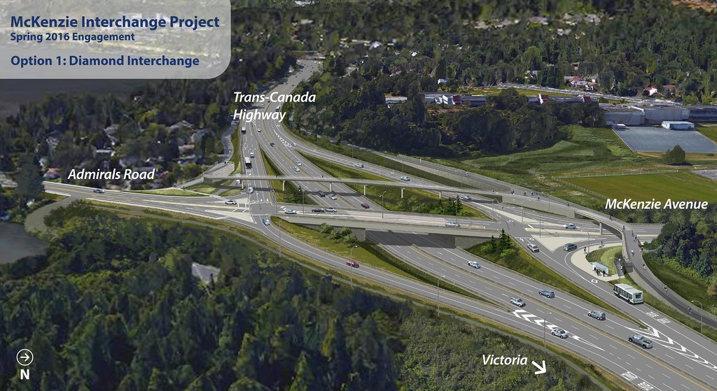 McKenzie Interchange Diamond Rendering by B.C. Ministry of Transportation and Infrastructure, on Flickr
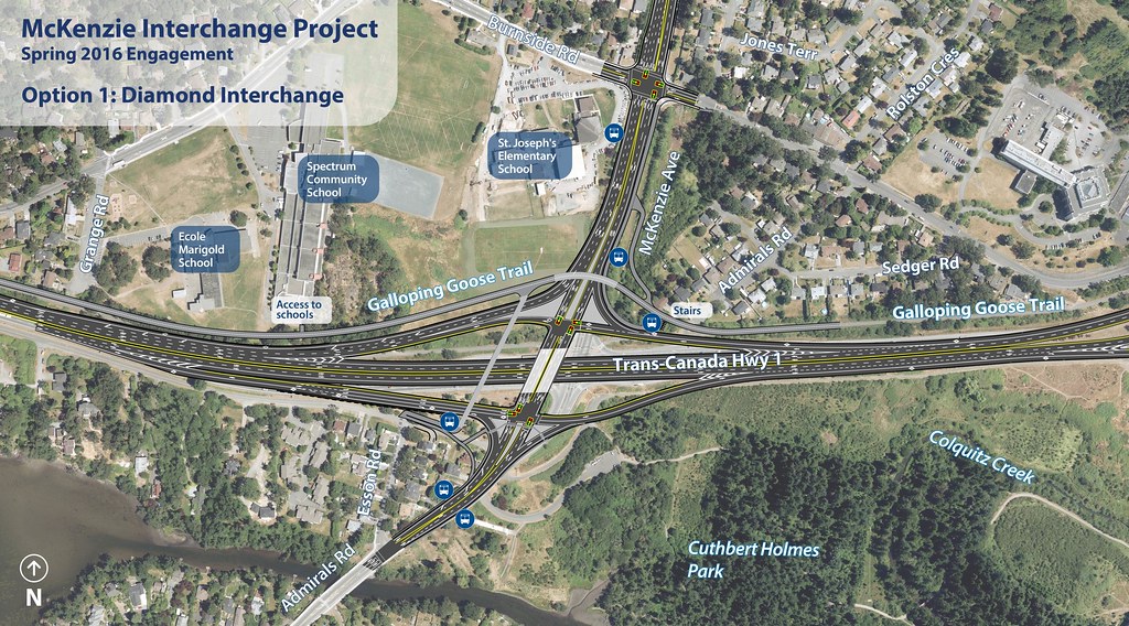 McKenzie Interchange Diamond Map by B.C. Ministry of Transportation and Infrastructure, on Flickr
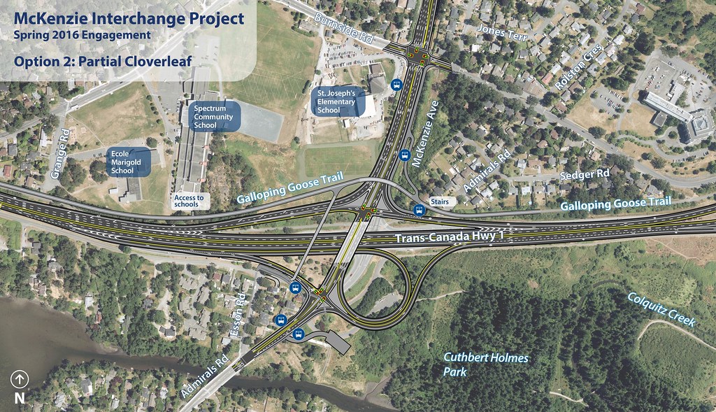 McKenzie Interchange Parial Cloverleaf Map by B.C. Ministry of Transportation and Infrastructure, on Flickr
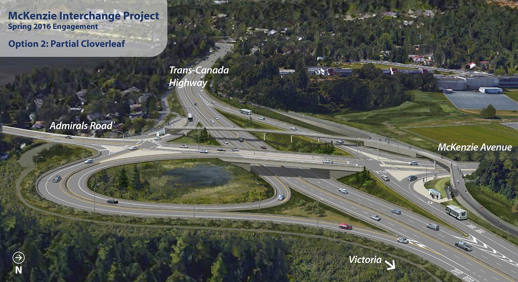 McKenzie Interchange Parial Cloverleaf Rendering by B.C. Ministry of Transportation and Infrastructure, on Flickr
how would someone with a scooter or bike get to the bus stop here? I think the sidewalk should be extended to the level part of the trail to make that bus stop more accessible. I don't even know what the long way around would be here, I guess they could go through the trees & come out on the mckenzie side? there's no close-up of the bus stop on the southbound side.
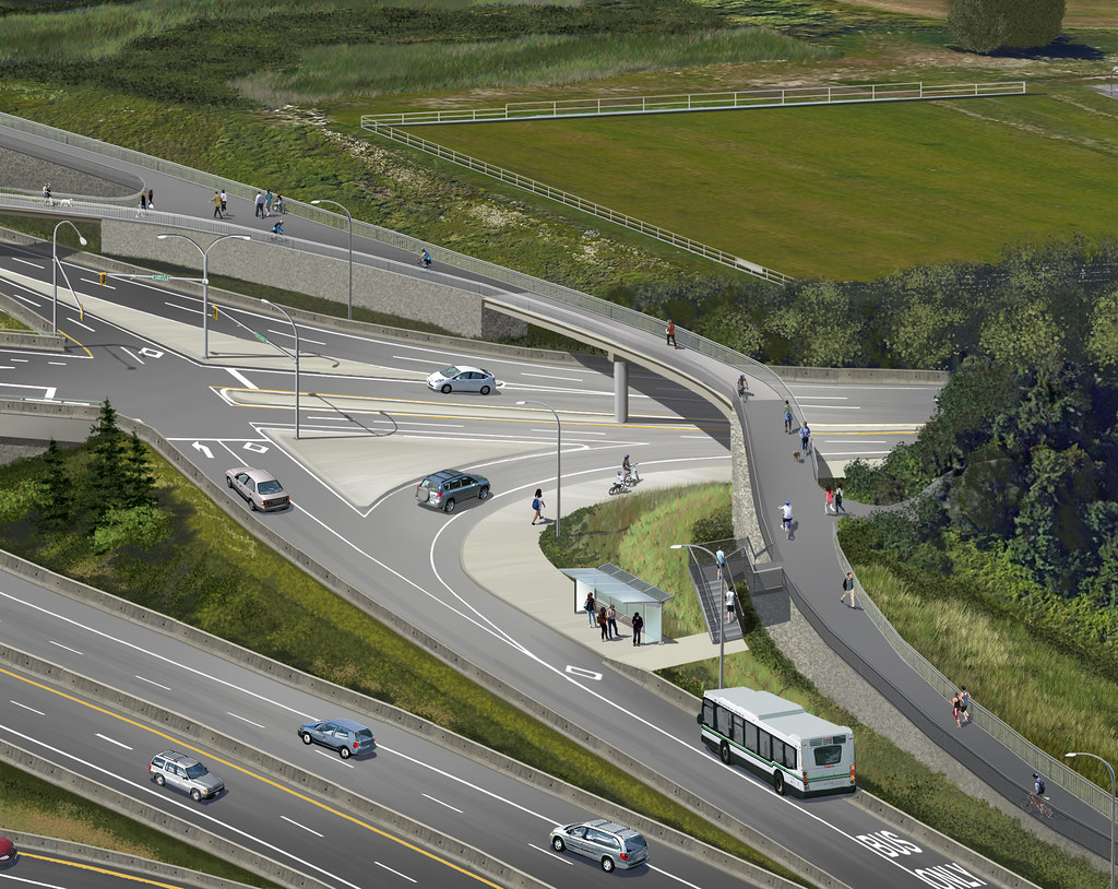 McKenzie Interchange - Galloping Goose Trail rendering by B.C. Ministry of Transportation and Infrastructure, on Flickr
http://www.timescolo...tions-1.2183989
McKenzie Interchange Diamond Rendering by B.C. Ministry of Transportation and Infrastructure, on FlickrMcKenzie Interchange Diamond Map by B.C. Ministry of Transportation and Infrastructure, on FlickrMcKenzie Interchange Parial Cloverleaf Map by B.C. Ministry of Transportation and Infrastructure, on FlickrMcKenzie Interchange Parial Cloverleaf Rendering by B.C. Ministry of Transportation and Infrastructure, on Flickrhow would someone with a scooter or bike get to the bus stop here? I think the sidewalk should be extended to the level part of the trail to make that bus stop more accessible. I don't even know what the long way around would be here, I guess they could go through the trees & come out on the mckenzie side? there's no close-up of the bus stop on the southbound side.
McKenzie Interchange - Galloping Goose Trail rendering by B.C. Ministry of Transportation and Infrastructure, on Flickr
#906
UrbanRail
-

- Member
- 2,114 posts
- LocationVictoria
Posted 25 February 2016 - 12:14 PM
noticed that in order to get a bus from the Goose, since there is no ramp just stairs, it will suck for people with mobility issues
#907
UrbanRail
-
- Member
- 2,114 posts
- LocationVictoria
Posted 25 February 2016 - 12:16 PM
is that a pond in the middle of the cloverleaf, sure would hate to be a fish or bird in that
#908
nagel
-
- Member
- 5,751 posts
Posted 25 February 2016 - 12:17 PM
Sidewalk up McKenzie then multi use trail back to goose, for wheelchairs. Otherwise elevator and they ain't putting that in.
#909
57WestHills
-

- Member
- 1,272 posts
Posted 25 February 2016 - 12:18 PM
Several people brought up the accessibility issue for non-motor vehicle traffic yesterday. Let's be honest the province has made up its mind on what it's doing and this is a show parade - honestly I don't have a huge issue with that - however, I do hope there continues to be some refinement around transit, future rapid transit, and pedestrian movement.
One thing I hadn't even considered until yesterday's open house was the pedestrian impact on the three schools that are right there. There was some valid, but unfortunately overly emotionally presented, points brought up by parents. I guess the current overpass for pedestrians would be gone. It adds actually a fair bit of distance to cross over to Admirals now. Also a portion of Portage will be removed regardless of which option is used.
One thing I hadn't even considered until yesterday's open house was the pedestrian impact on the three schools that are right there. There was some valid, but unfortunately overly emotionally presented, points brought up by parents. I guess the current overpass for pedestrians would be gone. It adds actually a fair bit of distance to cross over to Admirals now. Also a portion of Portage will be removed regardless of which option is used.
#910
nagel
-
- Member
- 5,751 posts
Posted 25 February 2016 - 12:27 PM
Several people brought up the accessibility issue for non-motor vehicle traffic yesterday. Let's be honest the province has made up its mind on what it's doing and this is a show parade - honestly I don't have a huge issue with that - however, I do hope there continues to be some refinement around transit, future rapid transit, and pedestrian movement.
One thing I hadn't even considered until yesterday's open house was the pedestrian impact on the three schools that are right there. There was some valid, but unfortunately overly emotionally presented, points brought up by parents. I guess the current overpass for pedestrians would be gone. It adds actually a fair bit of distance to cross over to Admirals now. Also a portion of Portage will be removed regardless of which option is used.
Yeah overpass is gone because it's not long enough or wheelchair friendly, and the new one will require a bit more of a walk because it's really sharing purposes with people who want to continue up McKenzie as well. I don't see a logical fix and think the overpass location is ok.
#911
UrbanRail
-
- Member
- 2,114 posts
- LocationVictoria
Posted 25 February 2016 - 12:28 PM
Several people brought up the accessibility issue for non-motor vehicle traffic yesterday. Let's be honest the province has made up its mind on what it's doing and this is a show parade - honestly I don't have a huge issue with that - however, I do hope there continues to be some refinement around transit, future rapid transit, and pedestrian movement.
One thing I hadn't even considered until yesterday's open house was the pedestrian impact on the three schools that are right there. There was some valid, but unfortunately overly emotionally presented, points brought up by parents. I guess the current overpass for pedestrians would be gone. It adds actually a fair bit of distance to cross over to Admirals now. Also a portion of Portage will be removed regardless of which option is used.
Yeah I noticed that the bus lane is intact coming up to the overpass going east in the diamond version, but is missing in the cloverleaf version, so buses have to navigate traffic to head back to the highway from the overpass in option 2 but not in option 1.
#912
G. Hanson
-

- Member
- 24 posts
Posted 26 February 2016 - 02:07 AM
Yeah I noticed that the bus lane is intact coming up to the overpass going east in the diamond version, but is missing in the cloverleaf version, so buses have to navigate traffic to head back to the highway from the overpass in option 2 but not in option 1.
Don't forget though that the Diamond option also requires all the northbound McKenzie traffic to use that exit, hence the need for a dedicated transit lane. On the cloverleaf option, the only other users of that exit would be vehicles turning south onto Admirals. According to the Ministry's figures it's only 3% of all inbound traffic that heads south on Admirals so I don't think it would be too much of an issue (if any at all) for busses to continue back onto the TCH.
#913
G. Hanson
-
- Member
- 24 posts
Posted 26 February 2016 - 02:09 AM
As for the Goose issue, it would absolutely ridiculous if the Ministry cannot find a bit of extra money to build a ramp up to the Goose from the NE transit stop where the stairs are. Build a ramp with a low grade heading back towards Tillicum right at the base of the proposed stairs. It's so simple it's ridiculous it wasn't included in these plans.
- Bingo likes this
#914
lanforod
-

- Member
- 11,324 posts
- LocationSaanich
Posted 26 February 2016 - 08:10 AM
As for the Goose issue, it would absolutely ridiculous if the Ministry cannot find a bit of extra money to build a ramp up to the Goose from the NE transit stop where the stairs are. Build a ramp with a low grade heading back towards Tillicum right at the base of the proposed stairs. It's so simple it's ridiculous it wasn't included in these plans.
I get that people are saying this, but I don't see how a ramp would be much shorter than going around down to McKenzie. If it is much shorter, the grade would be quite steep.
#915
D.L.
-

- Member
- 7,786 posts
Posted 26 February 2016 - 09:48 AM
Plus it would create another intersection of sorts on to the Goose, something which I think should be avoided in that location. Refer to this image here and consider what type of traffic patterns another connection to the Goose would create here - https://www.flickr.c...015251/sizes/h/
#916
Danma
-

- Member
- 888 posts
Posted 26 February 2016 - 03:16 PM
is that a pond in the middle of the cloverleaf, sure would hate to be a fish or bird in that
Somehow I think it'll be okay. Hundreds of rabbits thrive a minute west of here...
#917
Coreyburger
-

- Member
- 2,864 posts
Posted 27 February 2016 - 04:31 PM
The pond is for water quality, catching run-off from the road.
#918
Bingo
-
- Member
- 16,666 posts
Posted 27 February 2016 - 04:44 PM
The pond is for water quality, catching run-off from the road.
Hardly a symbiotic relationship, rabbit poo run-off and water quality.
#919
Coreyburger
-
- Member
- 2,864 posts
Posted 27 February 2016 - 06:22 PM
Hardly a symbiotic relationship, rabbit poo run-off and water quality.
Rabbit crap doesn't pollute water. Oil and heavy metals from cars does.
#920
lanforod
-
- Member
- 11,324 posts
- LocationSaanich
Posted 27 February 2016 - 08:31 PM
Rabbit crap doesn't pollute water. Oil and heavy metals from cars does.
I'll avoid drinking both rabbit crap water and bike lube oil and heavy metal polluted water thank you very much! IE. your definition of polluted is subjective.
You're not quite at the end of this discussion topic!
Use the page links at the lower-left to go to the next page to read additional posts.
Use the page links at the lower-left to go to the next page to read additional posts.


1 user(s) are reading this topic
0 members, 1 guests, 0 anonymous users

