Has anybody noticed they seem to be putting in a lot of shelters? At least that's what I assume they're doing. A number of stops along Glanford and Carey have had an area dug up and sectioned off. I also saw they seemed to be doing the same thing this morning on Hillside/Lansdowne at Shellbourne. One on Glanford has had a bunch of pylons on it covering where they dug for about a week now.

BC Transit (Victoria Regional Transit System) news and issues
Started by
Galvanized
, Aug 01 2006 10:55 AM
9623 replies to this topic
#5582
 news and issues: post #5582")
Nparker
-

- Member
- 40,712 posts
Posted 18 October 2017 - 11:44 AM
Has anybody noticed they seem to be putting in a lot of shelters? ...
Saanich must have a budget surplus they need to spend.
#5583
TallGuy
-

- Member
- 108 posts
Posted 18 October 2017 - 03:36 PM
I am talking here... not there. Sorry I was not clear enough.
Oh, and have you seen the size of the parkade at the downtown Costco, with FREE parking.
The parking is not free at the downtown Vancouver Costco. It is cheap though, relative to parking elsewhere downtown.
#5584
TallGuy
-
- Member
- 108 posts
Posted 18 October 2017 - 03:36 PM
Saanich must have a budget surplus they need to spend.
Why would Saanich pay for BC Transit's shelters?
#5585
VicHockeyFan
-

- Suspended User
- 52,121 posts
Posted 18 October 2017 - 03:37 PM
Why would Saanich pay for BC Transit's shelters?
To make Saanich more “liveable”.
- Nparker likes this
<p><span style="font-size:12px;"><em><span style="color:rgb(40,40,40);font-family:helvetica, arial, sans-serif;">"I don’t need a middle person in my pizza slice transaction" <strong>- zoomer, April 17, 2018</strong></span></em></span>
#5587
Cats4Hire
-

- Member
- 1,393 posts
Posted 18 October 2017 - 05:17 PM
Why would Saanich pay for BC Transit's shelters?
There's an election coming up (I believe next year) and Richard Atwell has done nothing but make people hate him since he was elected so he's probably trying to do a bunch of things to get people to like him before then. I doubt that many people will vote for him because he paid for like 5 bus shelters, one at a stop I rarely see used.
#5588
legaN
-

- Member
- 4 posts
Posted 18 October 2017 - 06:15 PM
There's an election coming up (I believe next year) and Richard Atwell has done nothing but make people hate him since he was elected so he's probably trying to do a bunch of things to get people to like him before then. I doubt that many people will vote for him because he paid for like 5 bus shelters, one at a stop I rarely see used.
While I agree with your assessment of his honor or whatever title I helped him regrettably earn, I seriously doubt he has much say in how many Transit shelters go in. Engineering staff are pretty empowered in this muni, and they massively support active transportation (which includes transit).
- 57WestHills likes this
#5589
Coreyburger
-

- Member
- 2,864 posts
Posted 19 October 2017 - 08:23 AM
This document may help answer your questions.
Injecting facts into a VV discussion. Should be ashamed of yourself. Hyperbole and hate on non-car modes all the way!
- VicHockeyFan, Nparker and grantpalin like this
#5590
thundergun
-

- Member
- 1,172 posts
- LocationVictoria
Posted 19 October 2017 - 10:38 AM
These shelters are not cheap so likely capitalized not expensed. Therefore likely part of a long term capital plan, 'not a spend it or we'll lose it' issue.
- VicHockeyFan likes this
#5591
Cats4Hire
-
- Member
- 1,393 posts
Posted 20 October 2017 - 03:52 PM
Didn't the schedules at stops used to mention if a bus continued as a different route (such as 30/31 -> 75 or 50 -> 61)? Some tourists were asking me about the 75 downtown today and I ended up having to use my phone to see when the next one came. I could have sworn there used to be a mark or something and off to the side it said that meant the route continues as a 75.
#5592
grantpalin
-

- Member
- 804 posts
Posted 20 October 2017 - 10:25 PM
Somebody's been chugging along for some time on a re-envisioning of the local bus schedule.
http://owenlett.com/...complete-draft/
- Mike K. likes this
#5593
Citified.ca
-

- Administrator
-

- 2,290 posts
- LocationVictoria, BC
Posted 22 October 2017 - 08:21 AM
It's a gorgeous rendition of the region's transit map, isn't it?
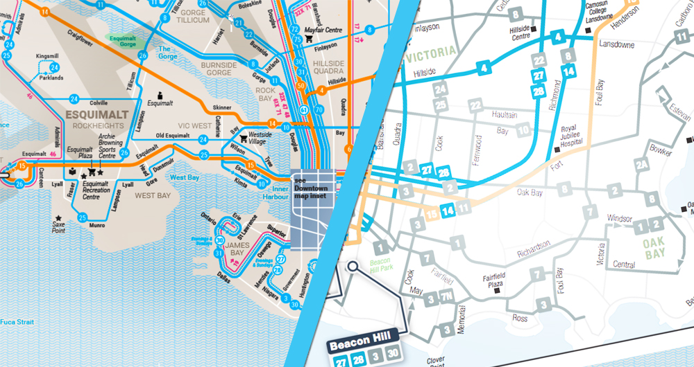
Owen Lett's BC Transit route map depicting fixed-route bus services throughout the Capital Region (left) as compared to the official map released by BC Transit. Lett released his rendition of Victoria's transit system map on October 19th.
Must-see BC Transit route map released by Victoria graphics artist
http://victoria.citi...raphics-artist/
- Bingo, tedward and thundergun like this
Know it all.
Citified.ca is Victoria's most comprehensive research resource for new-build homes and commercial spaces.
Citified.ca is Victoria's most comprehensive research resource for new-build homes and commercial spaces.
#5594
VicHockeyFan
-
- Suspended User
- 52,121 posts
Posted 22 October 2017 - 08:36 AM
Ya, that's very good. Man, I bet that #12 route is popular. BCT never really did a great job of connecting Gordon Head with UVic in the past.
<p><span style="font-size:12px;"><em><span style="color:rgb(40,40,40);font-family:helvetica, arial, sans-serif;">"I don’t need a middle person in my pizza slice transaction" <strong>- zoomer, April 17, 2018</strong></span></em></span>
#5595
grantpalin
-
- Member
- 804 posts
Posted 22 October 2017 - 09:46 AM
The #12 does get a good bit of use. Used to use it when I still attended UVic, and later when I would get on the #14 at the exchange to get to work.
I recall that there was another route that connected part of Gordon head to UVic long ago. It would go up Laval and turn right on Gordon Head Road, rather than left as the #27 does, and would terminate at UVic.
#5596
Cats4Hire
-
- Member
- 1,393 posts
Posted 03 November 2017 - 12:36 PM
The survey on Burnside/Tilicum makes no sense. One of the things they're asking is better connections to Douglas street. The 8, 11, 21, 22, 26 all either cross Douglas or drive directly on it. They also ask about better connecting the area with Hillside/Shellbourne. Route 8 already does that and I rarely see people use it for that purpose. I do agree with their need to minimize routes there. It's a pretty small area that has 5 routes. Not really sure how they could minimize that area though
#5597
sdwright.vic
-

- Member
- 6,685 posts
Colwood
Posted 03 November 2017 - 03:04 PM
What survey?
Predictive text and a tiny keyboard are not my friends!
#5598
Cats4Hire
-
- Member
- 1,393 posts
Posted 03 November 2017 - 03:48 PM
Weird there was one last night on this page: https://bctransit.co...rnside-tillicum
That still has all the information I was talking about though
That still has all the information I was talking about though
#5599
Cats4Hire
-
- Member
- 1,393 posts
Posted 05 November 2017 - 01:08 PM
While going through that local area transit plans page (https://bctransit.co...a-transit-plans) I noticed James Bay is listed as complete so I read the "Service Plan Final" pdf and it seems there are some pretty major changes happening in James Bay Jan 2018.
Firstly they are removing all current routes aside from route 3. 19 will no longer exist and 27 and 28 will always terminate at Blanshard. Routes 30 and 31 will terminate at Legislature.
They will be extending Route 2 (stays on Douglas until Niagara, up Menzies, down Superior to Dallas and loop back out via Oswego (no terminus anymore).
They will also be extending Route 3 up to Jubilee Hospital (via Foul Bay) and 10 to James Bay (via Wharf/Government and Johnson Bridge) with these two being "connected". Route 7 will also be connected to 21 instead of 2 now.
- Mike K. likes this
#5600
grantpalin
-
- Member
- 804 posts
Posted 05 November 2017 - 03:07 PM
Interesting. I used to live in the Goodacre buildings and made regular use of the routes terminating on Toronto at Huntington. That was useful for both getting into town and traveling into Gordon Head to visit family, and for getting back. The number of routes in the area was a little weird, and I can see the desire to simplify the landscape.
- VicHockeyFan likes this
You're not quite at the end of this discussion topic!
Use the page links at the lower-left to go to the next page to read additional posts.
Use the page links at the lower-left to go to the next page to read additional posts.


0 user(s) are reading this topic
0 members, 0 guests, 0 anonymous users

