There are gas pumps in Port Renfrew and Port Renfrew is West of the petro can so the petro can sign is incorrect

Pacific Marine Circle Route - Langford-Sooke-Port Renfrew-Lake Cowichan-Duncan
Started by
Mike K.
, Apr 28 2009 01:09 PM
119 replies to this topic
#82

phx
-

- Member
- 1,862 posts
Posted 30 June 2013 - 10:11 PM
Yeah, but it's primarily a marina, not a gas station.
#83
HB
-

- Banned
- 7,975 posts
Posted 30 June 2013 - 10:18 PM
The parking area on land has gas pumps for cars that pull up alongside and fill their tanks.
This is a station where cars get gas.
Boats can get gas at the piers.
Itr is not possible to drive a boat to the gas pumps unless of course its a hippo bus.
RVs Cars and Trucks fill up at the gas pumps which are on dry land near the RV Park office
Doesnt matter that the businees is called a marina the fact is that it is west of sooke and it sells gas. And it is not Primarily a marina it is also a place to buy food and it is also an RV Park
#84
phx
-
- Member
- 1,862 posts
Posted 30 June 2013 - 10:24 PM
Arguably, they are both correct.
When I said "arguably", I didn't actually want to argue about it!

#85
VicHockeyFan
-

- Suspended User
- 52,121 posts
Posted 01 July 2013 - 05:40 AM
I see. Well the PetroCan sign does say gas station, so yes I guess both correct.
<p><span style="font-size:12px;"><em><span style="color:rgb(40,40,40);font-family:helvetica, arial, sans-serif;">"I don’t need a middle person in my pizza slice transaction" <strong>- zoomer, April 17, 2018</strong></span></em></span>
#86
Mike K.
-
- Administrator
-

- 83,552 posts
Posted 01 July 2013 - 07:50 AM
Good luck to you if you need gas at 6PM on a January night out in Port Renfrew. The next closest gas station from that Petro Can in Sooke is in Lake Cowichan 130km away.
Speaking of this route, there is now a sign along HWY 14 heading out towards Sooke that lists the distance to Lake Cowichan.
Speaking of this route, there is now a sign along HWY 14 heading out towards Sooke that lists the distance to Lake Cowichan.
Know it all.
Citified.ca is Victoria's most comprehensive research resource for new-build homes and commercial spaces.
#87
eseedhouse
-

- Member
- 1,288 posts
Posted 01 July 2013 - 04:53 PM
There are gas pumps in Port Renfrew and Port Renfrew is West of the petro can so the petro can sign is incorrect
Actually, Port Renfrew is Northwest of the Western Communities and to the North most of Greater Victoria. Straight west from that gas station is the strait, and the first land on that bearing is in the United States, near Cape Flattery.
Straight west of Port Renfew is all ocean to Asia (with perhaps a small island or two along the way).
Port Renfrew is not directly to your West until you are North of Elk Lake, or on the Malahat, past Tunnel hill going North.
#88
VicHockeyFan
-
- Suspended User
- 52,121 posts
Posted 01 July 2013 - 05:02 PM
Actually, Port Renfrew is Northwest of the Western Communities and to the North most of Greater Victoria. Straight west from that gas station is the strait, and the first land on that bearing is in the United States, near Cape Flattery.
Straight west of Port Renfew is all ocean to Asia (with perhaps a small island or two along the way).
Port Renfrew is not directly to your West until you are North of Elk Lake, or on the Malahat, past Tunnel hill going North.
Is it more north, or more west of that sign in Sooke though. No sign is going to say "No more gas northwest of this station" so we need to know if it should say north, or west. NW does not cut it for signs.
<p><span style="font-size:12px;"><em><span style="color:rgb(40,40,40);font-family:helvetica, arial, sans-serif;">"I don’t need a middle person in my pizza slice transaction" <strong>- zoomer, April 17, 2018</strong></span></em></span>
#89
LJ
-
- Member
- 12,742 posts
Posted 01 July 2013 - 06:43 PM
I rode the route yesterday on my motorcycle, damn it was hot once you got east of Port Renfrew. Worst part of the road is from Jordan River to Renfrew.
Life's a journey......so roll down the window and enjoy the breeze.
#90
G-Man
-

- Moderator
-

- 13,805 posts
Senior Case Officer
Posted 01 July 2013 - 06:57 PM
^ how was the new bridge?
#91
Linear Thinker
-

- Member
- 522 posts
- LocationWork from home, Live in Fairfield
Posted 02 July 2013 - 08:59 AM
History Buff / phx:
The Marina's site says they are only open May-October.
Can either of confirm this is true? Unless you're talking about a different marina.
(btw, map link to the marina location)
Throwing the marina's potential winter closure into the mix, the sign that says no gas for 79km is only correct 6 months of the year.
Yeah, but it's primarily a marina, not a gas station.
#92
HB
-
- Banned
- 7,975 posts
Posted 02 July 2013 - 09:36 AM
Lets start a new thread about the drive from Port Albernin to Ucluelet. That ones a lot farter that Sooke to Renfrew.
How do people manage?
Ucluelet is over 100km west of Port Alberni....
Now I wait for someone to correct this and mention that it is actually 236° south west
How do people manage?
Ucluelet is over 100km west of Port Alberni....
Now I wait for someone to correct this and mention that it is actually 236° south west
#93
jonny
-

- Member
- 9,211 posts
Posted 02 July 2013 - 09:40 AM
^ how was the new bridge?
Stupid and boring!

They got rid of one of the more interesting parts of that road.
I do not think you should count on being able to buy gas in Port Renfrew. I think you can buy it at the marina, but I believe it is marked gas? I've never tried, but that's what I have been told. I always head out there with enough gas to get back!
#94
sebberry
-

- Moderator
-
- 21,508 posts
Resident Housekeeper
- LocationVictoria
Posted 02 July 2013 - 10:13 AM
Stupid and boring!
They got rid of one of the more interesting parts of that road.
What did they do to which bridge? I haven't been out there for a while.
Victoria current weather by neighbourhood: Victoria school-based weather station network
Victoria webcams: Big Wave Dave Webcams
#95
HB
-
- Banned
- 7,975 posts
Posted 02 July 2013 - 10:45 AM
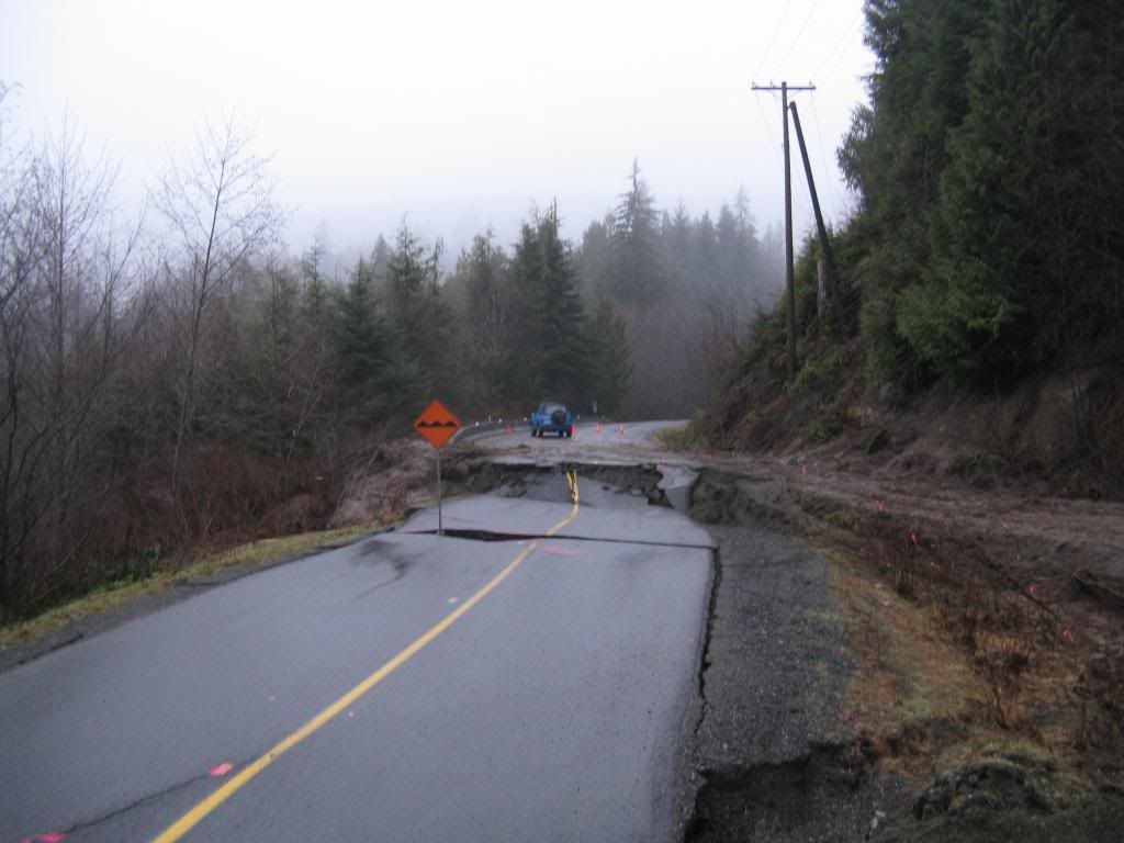
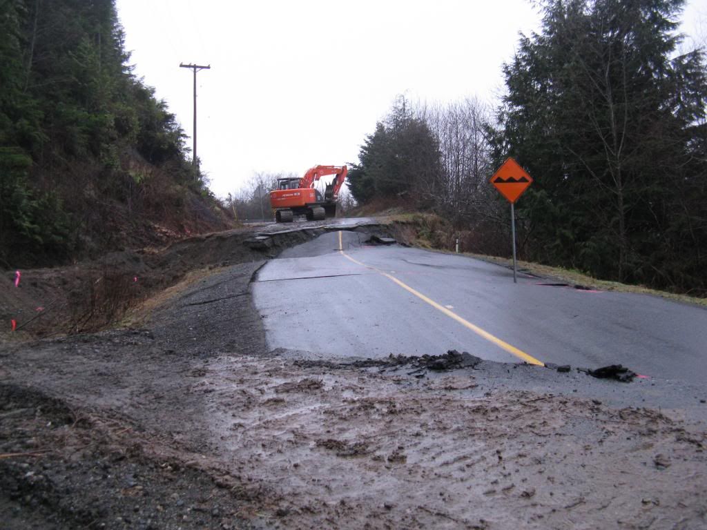
They built a new bridge over an arm of the Sombrio river just east of the no. 2 Sombrio wher ethe bridge with blue railings is.
there is a new diversion to the bridge which starts just at the Sombrio Beach access rd.
It replaces a very unstable portion of the road that was subject to slides and slumping.
The new road and bridge access is awesome because it is higher elevation with great views compared to the old road and the view to the Sombrio under the brige is nice
Like in this photo taken a couple years ago. this section is not part of the road any longer.I took these shots in Jan 09
#96
VicHockeyFan
-
- Suspended User
- 52,121 posts
Posted 02 July 2013 - 10:56 AM
^ That warning sign is a little understated for the hazard ahead. 
<p><span style="font-size:12px;"><em><span style="color:rgb(40,40,40);font-family:helvetica, arial, sans-serif;">"I don’t need a middle person in my pizza slice transaction" <strong>- zoomer, April 17, 2018</strong></span></em></span>
#97
Mike K.
-
- Administrator
-
- 83,552 posts
Posted 02 July 2013 - 11:05 AM
Hilarious
Know it all.
Citified.ca is Victoria's most comprehensive research resource for new-build homes and commercial spaces.
#98
jonny
-
- Member
- 9,211 posts
Posted 02 July 2013 - 11:44 AM
They built a new bridge over an arm of the Sombrio river just east of the no. 2 Sombrio wher ethe bridge with blue railings is.
there is a new diversion to the bridge which starts just at the Sombrio Beach access rd.
It replaces a very unstable portion of the road that was subject to slides and slumping.
The new road and bridge access is awesome because it is higher elevation with great views compared to the old road and the view to the Sombrio under the brige is nice.
The new bridge and set-up is definitely safer and quicker, but it's definitely less interesting to navigate through!
As HB said, it's right before the blue bridge when you're heading out to Renfrew. Heading east, there used to be one way section due to some of the road giving way followed by a downhill portion which led to one of the one way wooden bridges. Then there was a 90 degree uphill right turn followed by a nearly hairpin left turning switchback on a very steep incline followed by a hard, sweeping right corner which led up to an awesome sweeping left onto the bridge with blue railings.
#99
Nanaimoite
-

- Member
- 158 posts
Posted 02 July 2013 - 09:25 PM
its an awesome route to take, driven it many times Nanaimo to Victoria, its suprising how many people don't know its paved all the way
#100
Bernard
-
- Member
- 5,056 posts
- LocationVictoria BC
Posted 22 January 2014 - 03:33 PM
Here is a cool time lapse video of the building of the Sombrio bridge
http://youtu.be/jdl1OOK7kMQ
- Bingo and D.L. like this
You're not quite at the end of this discussion topic!
Use the page links at the lower-left to go to the next page to read additional posts.
Use the page links at the lower-left to go to the next page to read additional posts.


1 user(s) are reading this topic
0 members, 1 guests, 0 anonymous users

