Jump to content


Photo

Aerial Photos of BC from 1940's and 1950's


  • Please log in to reply
211 replies to this topic

#181 Sparky

Sparky

    GET OFF MY LAWN

  • Moderator
  • 13,140 posts

Posted 14 November 2012 - 11:37 PM

I was there in 1953, but it could have been built before that.


So if the aerial picture was taken in 1951 and you attended in 1953...I'm going to go out on a limb here and say that it was built in 1952....or thereabouts. Thanks for that Bingo. Geezus you are old. :)

#182 Bingo

Bingo
  • Member
  • 16,666 posts

Posted 15 November 2012 - 07:36 AM

So if the aerial picture was taken in 1951 and you attended in 1953...I'm going to go out on a limb here and say that it was built in 1952....or thereabouts. Thanks for that Bingo. Geezus you are old. :)


It looks like there might be some construction going on in the photo. A large fence, some clearing, the concession and projection buildings.

We used to go on Friday nights in the summer and play bingo in the car until the movie started. If you got a bingo you tooted the horn. We won 20 bucks once.

I saw "The African Queen" at that Drive-in. The movie that is! ;)

#183 wisevictoria

wisevictoria
  • Member
  • 119 posts
  • Location225 Dundas Street, Victoria, BC

Posted 15 November 2012 - 12:23 PM

Fantastic photos. I will spend hours looknig at these.

#184 MarkP

MarkP
  • Member
  • 31 posts

Posted 02 May 2013 - 01:52 PM

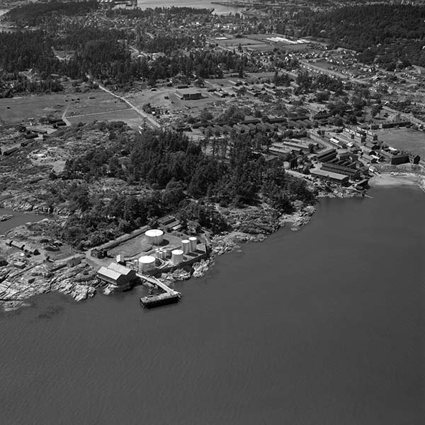
Hey guys, I found another "Victoria" image but I have no idea where it is located and I was hoping someone could help me out? It's a little blurry, but has some neat content. The image is labelled "Imperial Oil Victoria Harbour". I'll attached a reduced resolution version here:


Can someone tell me where this is?

Thanks,
Mark

#185 Bingo

Bingo
  • Member
  • 16,666 posts

Posted 02 May 2013 - 02:04 PM

It looks like Work Point to the right, when it was more active as a military complex.

Part of Esquimalt Harbour is at the top of the image. The tank farm at left was Imperial Oil

Hey guys, I found another "Victoria" image but I have no idea where it is located and I was hoping someone could help me out? It's a little blurry, but has some neat content. The image is labelled "Imperial Oil Victoria Harbour". I'll attached a reduced resolution version here:


Can someone tell me where this is?

Thanks,
Mark


#186 Sparky

Sparky

    GET OFF MY LAWN

  • Moderator
  • 13,140 posts

Posted 02 May 2013 - 03:05 PM

^ I would say that you are bang on Bingo. I first thought that the body of water at the top of the picture might have been Portage inlet, but that hill with the trees didn't agree with my theory. Those trees should be Rock Heights before the houses were built.

#187 HB

HB
  • Banned
  • 7,975 posts

Posted 02 May 2013 - 03:37 PM

You are right spark the tank farm was only dismantled a few years ago the footing and containment walls still stand you can see west bay on the right side of photo

#188 Bingo

Bingo
  • Member
  • 16,666 posts

Posted 02 May 2013 - 04:02 PM

You are right spark the tank farm was only dismantled a few years ago the footing and containment walls still stand you can see west bay on the right side of photo


The small beach at the right is now protected by a breakwater and the Esquimalt Boat Club has it's docks there. The old parade square is just above the beach.

The road that angles up to the top left of the photo is Bewdley. I think the Old England Inn is just above the large building in the middle of the photo.


#189 MarkP

MarkP
  • Member
  • 31 posts

Posted 02 May 2013 - 04:38 PM

Thanks a lot guys. You got me exactly in the right location. I've posted the full image now if you want to zoom in.

http://vintageairpho...com/bo-47-1453/

Thanks again,
Mark

#190 Bingo

Bingo
  • Member
  • 16,666 posts

Posted 02 May 2013 - 10:21 PM

I'm guessing the date to be late 1930's.

You can see the old gun emplacements on the rocks up behind the oil tanks. The United Church is at Lyall and Admirals, and there are a few navy ships at the jettys in Esquimalt Harbour.

compare photo to Google Maps.
http://maps.google.com/

#191 MarkP

MarkP
  • Member
  • 31 posts

Posted 31 May 2013 - 10:11 PM

I'm guessing the date to be late 1930's.


'Twas 1947.

Just posted a new one. Also 1947. Kind of Hudson Bay Store looking south-east.

http://vintageairpho...com/bo-47-1450/

Mark

#192 G-Man

G-Man

    Senior Case Officer

  • Moderator
  • 13,805 posts

Posted 31 May 2013 - 10:36 PM

That is a great photo! I had no idea that we lost a number of great little buildings in the creation of Centennial Square. I had really only heard about the market.

Visit my blog at: https://www.sidewalkingvictoria.com 


It has a whole new look!


#193 Sparky

Sparky

    GET OFF MY LAWN

  • Moderator
  • 13,140 posts

Posted 31 May 2013 - 11:11 PM

MarkP you are a true vibrantvictoria treasure. Bless you.

#194 sebberry

sebberry

    Resident Housekeeper

  • Moderator
  • 21,507 posts
  • LocationVictoria

Posted 31 May 2013 - 11:37 PM

I love looking back at these old photos of Victoria :)

Victoria current weather by neighbourhood: Victoria school-based weather station network

Victoria webcams: Big Wave Dave Webcams


#195 HB

HB
  • Banned
  • 7,975 posts

Posted 31 May 2013 - 11:38 PM

Great Photo thanks for sharing. Your date is very accurate too. Summer of 47.

This I know because the leaves are on the trees and the Odeon theatre which opened in Feb 48 is under construction.


Now may favorite parts of the image are as follows.

People Playing Tennis on 3 courts behind Chinese Public school
Odd Fellows Hall has not yet been raped by layers of stucco hiding the awesome windows.
The HBC rear addiction is not there yet only the original building.
Blanshard St ends at Panora has not been extended yet

The railyards you see are where the current Capitol Iron Parking lot is. those rails have not been gone all that long I remember them

I have a video on my computer of the wrecking ball on a crane smashing the buildings on Cormorant St where Centennial Sq is now.

#196 HB

HB
  • Banned
  • 7,975 posts

Posted 01 June 2013 - 12:27 AM

From the Federal Building at Government at Yates to Fisguard st at Centennial Square which contruction at has just been completed

I0r98r3Ap9s

#197 VicHockeyFan

VicHockeyFan
  • Suspended User
  • 52,121 posts

Posted 01 June 2013 - 01:00 AM


Robert McIntyre Photography
<p><span style="font-size:12px;"><em><span style="color:rgb(40,40,40);font-family:helvetica, arial, sans-serif;">"I don’t need a middle person in my pizza slice transaction" <strong>- zoomer, April 17, 2018</strong></span></em></span>

#198 Mike K.

Mike K.
  • Administrator
  • 83,433 posts

Posted 01 June 2013 - 07:35 AM

That photo better be from the 40's or 50's, VHF! ;)

Know it all.
Citified.ca is Victoria's most comprehensive research resource for new-build homes and commercial spaces.


#199 E-P-G

E-P-G
  • Member
  • 16 posts

Posted 01 June 2013 - 01:23 PM

Great Photo thanks for sharing. Your date is very accurate too. Summer of 47.

Now may favorite parts of the image are as follows.

People Playing Tennis on 3 courts behind Chinese Public school
Odd Fellows Hall has not yet been raped by layers of stucco hiding the awesome windows.
The HBC rear addiction is not there yet only the original building.
Blanshard St ends at Panora has not been extended yet


Oh cool, I see what you mean about Blanshard Street "ending" heading north at Pandora. I guess the street continuing north a bit to the west is the part that's now also Blanshard (jut added later), might have been "Rose" then?

#200 Bingo

Bingo
  • Member
  • 16,666 posts

Posted 01 June 2013 - 04:55 PM

Have a look at the southwest corner of Christ Church Cathedral under construction.

You're not quite at the end of this discussion topic!

Use the page links at the lower-left to go to the next page to read additional posts.


0 user(s) are reading this topic

0 members, 0 guests, 0 anonymous users