I am not talking about Smith Hill reservoir and never have been in this thread, but I agree, that one is square.
The summit reservoir I am talking about is the one on the very top of Mt Tolmie that is roughly 50 X 150 feet, and is not square. You can see both the Mt Tolmie reservoir and the Cromwell Reservoir on Google Maps and use the scale at the bottom to determine their size. Those images are what I am using to back up some of my claims.
I often walk in that area and there are quite a few homes that are at a higher elevation than the Cromwell reservoir.
As to the original topic of this thread, I don't think that Saanich constructed a reservior out of the foundation of a WW II radio building.

Fake buildings/disguised uses
Started by
Holden West
, May 04 2013 07:29 AM
72 replies to this topic
#42

HB
-

- Banned
- 7,975 posts
Posted 08 May 2013 - 07:42 AM
The Tolmie reservoir is called and known as the Tolmie reservoir not summit reservoir.
The summit reservoir is also known as smith hill reservoir
The summit reservoir is also known as smith hill reservoir
#43
HB
-
- Banned
- 7,975 posts
Posted 08 May 2013 - 07:56 AM
I often walk in that area and there are quite a few homes that are at a higher elevation than the Cromwell reservoir.
Yes very good.
Now when water from cromwell is used where does the replcement water come from??????
Hold on Ill answer that.
It comes from the Mt Tolmie reservoir which again is the highest point in the water supply for Oak Bay.
The 2 are connected so think of them as one system.
#44
VicHockeyFan
-

- Suspended User
- 52,121 posts
Posted 08 May 2013 - 08:07 AM
For purposes on non-confusion, let's name the reservoirs, as the term "summit" has been misleading some.
In the order they were built:
#1 Summit or Smith Hill reservoir.
#2 Cromwell Mt. Tolmie reservoir.
#3 Mt. Tolmie highest reservoir.
In the order they were built:
#1 Summit or Smith Hill reservoir.
#2 Cromwell Mt. Tolmie reservoir.
#3 Mt. Tolmie highest reservoir.
<p><span style="font-size:12px;"><em><span style="color:rgb(40,40,40);font-family:helvetica, arial, sans-serif;">"I don’t need a middle person in my pizza slice transaction" <strong>- zoomer, April 17, 2018</strong></span></em></span>

#46
phx
-

- Member
- 1,862 posts
Posted 08 May 2013 - 09:51 AM
HB, the way it likely works is this: the water flows from Sooke through pipes into the reservoir. When the reservoir is full, a valve closes stopping the inflow of water. The water then flows by gravity through other pipes to the neighbourhood. The water in the reservoir is not under pressure. It is possible to build a pressurized reservoir, but there is no reason to in this case.
#47
G-Man
-

- Moderator
-

- 13,805 posts
Senior Case Officer
Posted 08 May 2013 - 09:57 AM
I think HB is saying that the Cromwell Resevoir is pressurized by gravity from the Tolmie Resevoir.
#48
HB
-
- Banned
- 7,975 posts
Posted 08 May 2013 - 10:44 AM
I just had a look at the water infrastructure on Saanich.ca website
They have Gis maps with overlays
I was partially wrong and apologie for not having all of MY facts in order
From what I just looked at the Cromwell reservoir has 3 or more pumps in or on it
Water comes into the Cromwell res from the CRD mumber 3 main it is then pumped from Cromwell UP to The Reservoir on Mr Tolmie
From Mt Tolmie it is gravity fed to surrounding areas including UVIC
The reason I was incorrect in my previous posting was because the Crd water maps and the Japan Gulch computers show only the water main ending at Mt Tolmie and there is no diagram or notation of Cromwell so they consider it all one system
#49
Bingo
-

- Member
- 16,666 posts
Posted 08 May 2013 - 01:06 PM
I talked with someone at Saanich, and the reservoir at the top of Mt Tolmie is theirs, and it supplies water to areas of Saanich. It appears that the water is pumped up from the CRD's Mt. Tolmie Resevoir in Oak Bay which is located on Cromwell Road.
The District of Saanich has an excellent GIS Mapping Service which lets you access various bits of information.
http://www.saanich.c...ite=saanich_axl
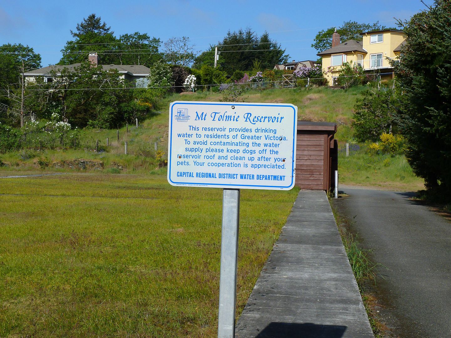
Here is Saanich's reservoir near the top of Mt. Tolmie, which used to be open, but now has a lid.
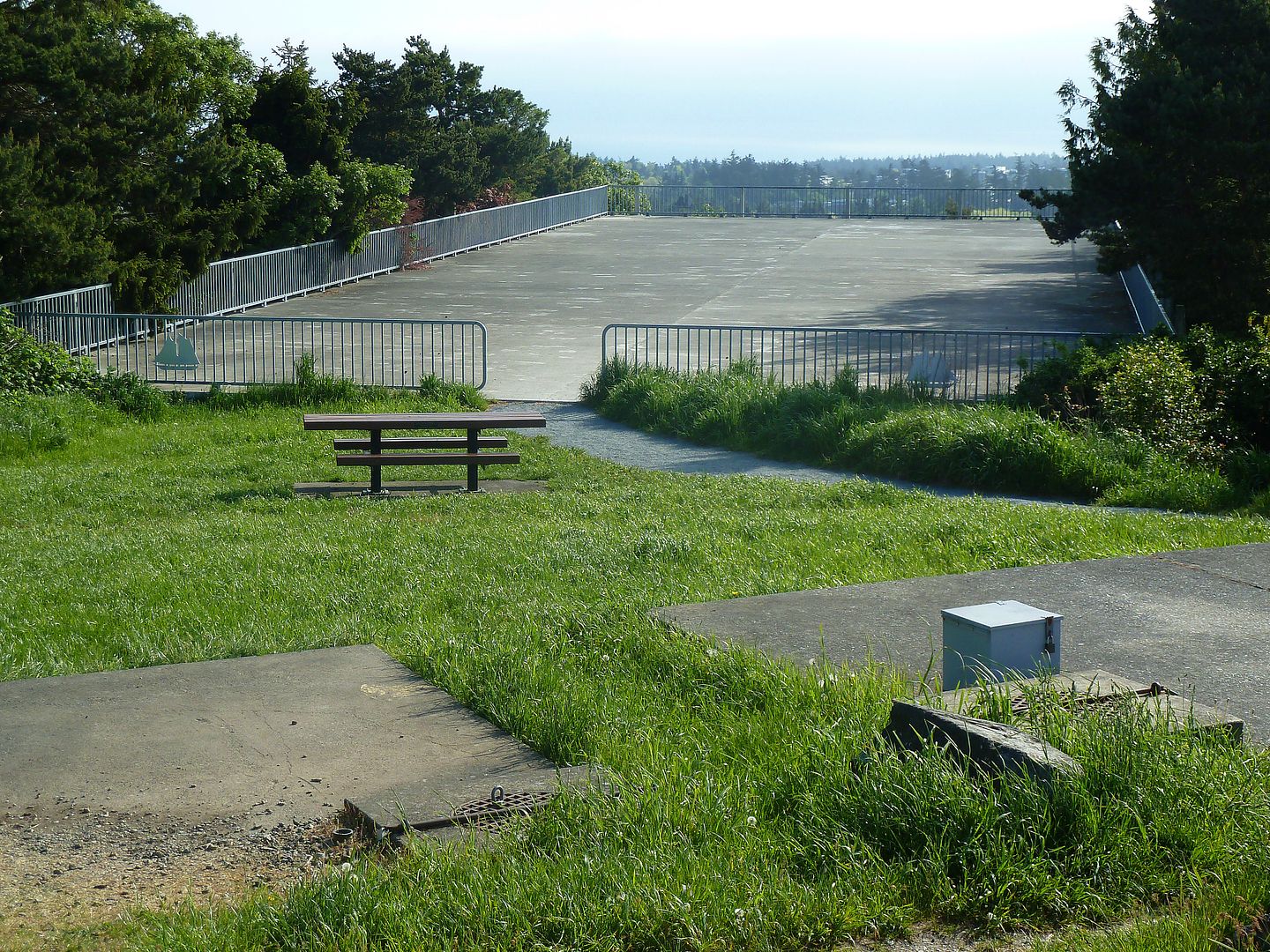
Here is the CRD's Mt. Tolmie Reservoir on Cromwell Road. The top of Mt. Tolmie Park and reservoir is above the houses and to the right.
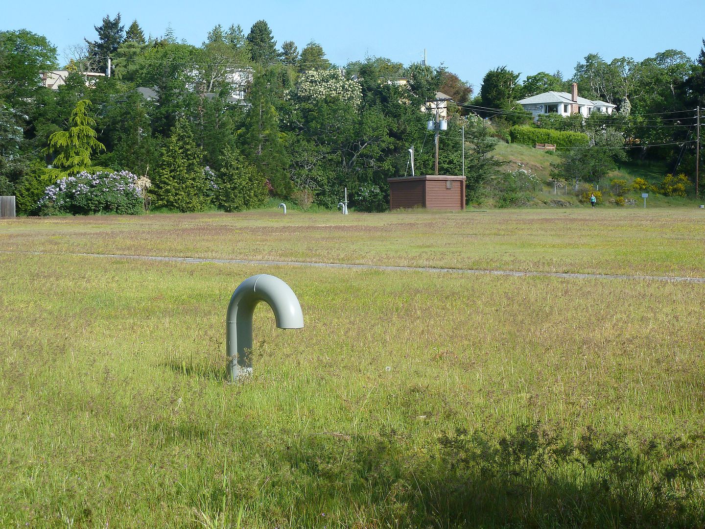
Another view of the sports sized field which covers the Mt. Tolmie Reservoir.
The District of Saanich has an excellent GIS Mapping Service which lets you access various bits of information.
http://www.saanich.c...ite=saanich_axl
Here is Saanich's reservoir near the top of Mt. Tolmie, which used to be open, but now has a lid.
Here is the CRD's Mt. Tolmie Reservoir on Cromwell Road. The top of Mt. Tolmie Park and reservoir is above the houses and to the right.
Another view of the sports sized field which covers the Mt. Tolmie Reservoir.
#50
Bingo
-
- Member
- 16,666 posts
Posted 08 May 2013 - 01:24 PM
By the way, I haven't had this much fun since that telephoto shot of Victoria taken near Port Angeles was posted.
#51
HB
-
- Banned
- 7,975 posts
Posted 08 May 2013 - 01:46 PM
Here is Saanich's reservoir near the top of Mt. Tolmie, which used to be open, but now has a lid.
That always had a top on it the photos of it when it is brand new shows a roof on it and in the photo where they are filling it the 14 fr columns are holding up the roof
Please supply your photos or documentation that shows it with no top on it or the construction of the top
Sheesh
It's ok to be wrong at times
#52
sebberry
-

- Moderator
-
- 21,507 posts
Resident Housekeeper
- LocationVictoria
Posted 08 May 2013 - 02:35 PM
I think the photo of the columns is for the Cromwell reservoir, no? The fuzzy caption says something about topsoil being spread over top.
Victoria current weather by neighbourhood: Victoria school-based weather station network
Victoria webcams: Big Wave Dave Webcams
#53
HB
-
- Banned
- 7,975 posts
Posted 08 May 2013 - 03:03 PM
I'm done with this subject I think we can all agree that they are 2 concrete boxes with water in them
On to more pressing matters now such as the massive crane lifting old HVAC units off the library roof on Broughton st then lifting new ones up
On to more pressing matters now such as the massive crane lifting old HVAC units off the library roof on Broughton st then lifting new ones up
#54
VicHockeyFan
-
- Suspended User
- 52,121 posts
Posted 08 May 2013 - 03:55 PM
On to more pressing matters now such as the massive crane lifting old HVAC units off the library roof on Broughton st then lifting new ones up
On it!

<p><span style="font-size:12px;"><em><span style="color:rgb(40,40,40);font-family:helvetica, arial, sans-serif;">"I don’t need a middle person in my pizza slice transaction" <strong>- zoomer, April 17, 2018</strong></span></em></span>
#55
aastra
-

- Member
- 20,741 posts
Posted 08 May 2013 - 04:18 PM
I took your word for it and assumed that this was the one I was thinking of but it turns out that I was thinking of another one, the Rithet Reservoir just a bit further south off of Boulderwood Drive. So many reservoirs, so little time.^ There is a reservoir on the south end of Wesely on Claremont ridge.
#56
Sparky
-

- Moderator
-
- 13,141 posts
GET OFF MY LAWN
Posted 08 May 2013 - 05:12 PM
^ Right, I see them both.
#57
VicHockeyFan
-
- Suspended User
- 52,121 posts
Posted 08 May 2013 - 05:46 PM
Water, water everywhere, but our information stinks.
<p><span style="font-size:12px;"><em><span style="color:rgb(40,40,40);font-family:helvetica, arial, sans-serif;">"I don’t need a middle person in my pizza slice transaction" <strong>- zoomer, April 17, 2018</strong></span></em></span>
#58
phx
-
- Member
- 1,862 posts
Posted 08 May 2013 - 05:53 PM
It was mentioned that the Smith Hill reservoir is for emergencies and not otherwise used. Is the water in it stagnant? If so, it would get a bit foul.
#59
VicHockeyFan
-
- Suspended User
- 52,121 posts
Posted 08 May 2013 - 06:39 PM


That thing is huge. (that's what she said).
http://www.bulgarcom...=104&Itemid=121
Max. lifting capacity: 130t
Boom: 12.8 to 60m.
6ZYDKdV4vnc
<p><span style="font-size:12px;"><em><span style="color:rgb(40,40,40);font-family:helvetica, arial, sans-serif;">"I don’t need a middle person in my pizza slice transaction" <strong>- zoomer, April 17, 2018</strong></span></em></span>
#60
G-Man
-
- Moderator
-
- 13,805 posts
Senior Case Officer
Posted 08 May 2013 - 07:06 PM
So it looks like a crane what does it actually do?
You're not quite at the end of this discussion topic!
Use the page links at the lower-left to go to the next page to read additional posts.
Use the page links at the lower-left to go to the next page to read additional posts.


0 user(s) are reading this topic
0 members, 0 guests, 0 anonymous users

