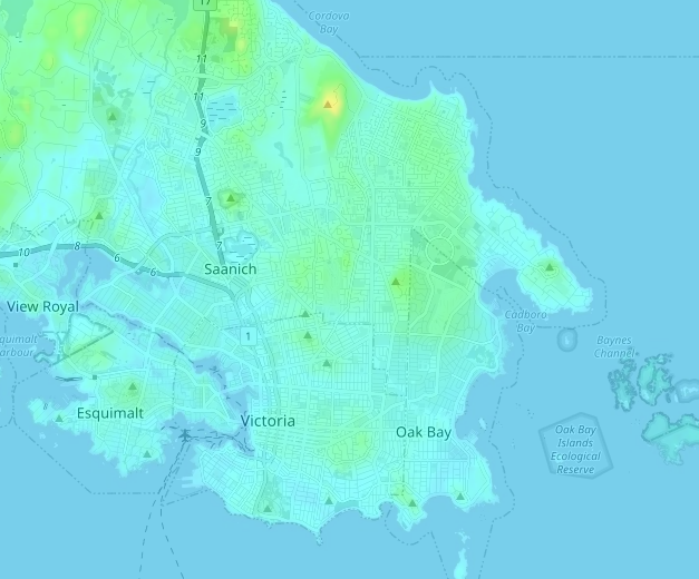
Can you name all the hills without looking them up? I only got about half.
Edited by Victoria Watcher, 07 February 2023 - 08:12 AM.
Old White Man On A Canadian Island
Posted 07 February 2023 - 08:11 AM
Can you name all the hills without looking them up? I only got about half.
Edited by Victoria Watcher, 07 February 2023 - 08:12 AM.
Old White Man On A Canadian Island
Posted 07 February 2023 - 08:14 AM
Easy ones:

Old White Man On A Canadian Island
Posted 07 February 2023 - 08:17 AM
This one might be a little under-rated because I'm not sure of there is a look-out at all.

But houses on both sides of Doncaster have great views. The view over the golf course is quite something.
Edited by Victoria Watcher, 07 February 2023 - 08:19 AM.

Posted 07 February 2023 - 08:19 AM
Know it all.
Citified.ca is Victoria's most comprehensive research resource for new-build homes and commercial spaces.
Old White Man On A Canadian Island
Posted 07 February 2023 - 08:26 AM
Yeah that’s one of the hidden gem neighbourhoods.
This is facing north on Cedar Hill Road, just past Doncaster school.

Edited by Victoria Watcher, 07 February 2023 - 08:26 AM.
Old White Man On A Canadian Island
Posted 07 February 2023 - 08:28 AM
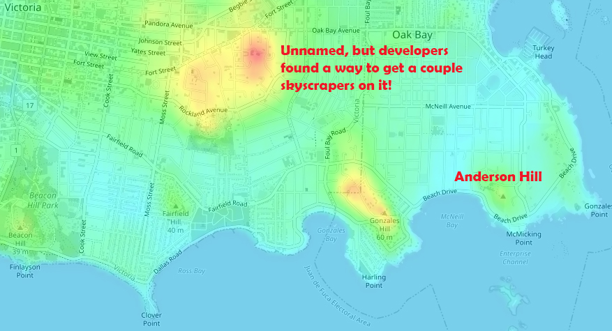
At 77m this is Prevost Hill.

For reference, Mt. Tolmie is 120m.

That reminds me, Ten Mile Point will really be something when Missing Middle comes.
Edited by Victoria Watcher, 07 February 2023 - 08:31 AM.
Old White Man On A Canadian Island
Posted 07 February 2023 - 08:35 AM
Old White Man On A Canadian Island
Posted 07 February 2023 - 08:42 AM
A couple hills in Saanich. I think the upper one has a water reservoir.

Old White Man On A Canadian Island
Posted 07 February 2023 - 08:49 AM
Today we walked 5km on the trail. We first walked Cedar Hill then Henderson. We took a drive in Saanich to Bossi Rd. where we found the road up to the Wesley Reservoir. For those paying attention, you will recall the Boulderwood Park Trail passed by this monolth. We added a few more flickr photos of this interesting structure after walking the 250m on the access road.

https://www.flickr.c...is21/3335840880

^ Wesley Reservoir.
Old White Man On A Canadian Island
Posted 07 February 2023 - 08:52 AM

You'll notice this one if you drive up Parklands.
Old White Man On A Canadian Island
Posted 07 February 2023 - 08:54 AM
Never heard of Grant Knoll or Black Rock until today.
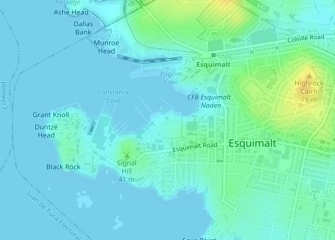
Signal Hill:

Edited by Victoria Watcher, 07 February 2023 - 08:56 AM.
BUILD
Posted 07 February 2023 - 08:56 AM
^^^ I've never figured out what the concrete building is but it's not a reservoir afaik; the reservoir is on in the lower one
^^ or play hole 12. the hill on hole 6 (or what used to be hole 6) has a better view though iirc.
In the original image i can see beacon hill, moss rock & gonzales hill, and the others in victoria are summit hill (?) and peacock hill at the end of tolmie ave. observatory hill (aka little saanich mountain) is in the northwest. the one is view royal is in thetis lake park which is much bigger than it looks. there's a hill with two peaks one of which is scafe hill & I forget the other. or maybe that's a bit farther north but still in the park.
Edited by amor de cosmos, 07 February 2023 - 11:34 AM.
Old White Man On A Canadian Island
Posted 07 February 2023 - 08:58 AM

Is there two Mt. Dougs?
There certainly is another peak, opposite of where the lookout structure is (where the antennae is).


Edited by Victoria Watcher, 07 February 2023 - 09:01 AM.
Old White Man On A Canadian Island
Posted 07 February 2023 - 09:04 AM
^^^ I've never figured out what the concrete building is but it's not a reservoir afaik; the reservoir is on in the lower one
^^ or play hole 12. the hill on hole 6 (or what used to be hole 6) has a better view though iirc.
In the original image i can see beacon hill, moss rock & observatory hill, and the others in victoria are summit hill (?) and peacock hill at the end of tolmie ave. observatory hill (aka little saanich mountain) is in the northwest. the one is view royal is in thetis lake park which is much bigger than it looks. there's a hill with two peaks one of which is scafe hill & I forget the other. or maybe that's a bit farther north but still in the park.
Saanich Distribution System – District of Saanich
In 2021, drinking water was supplied to the Saanich Distribution System at a number of points from the CRD’s transmission mains. Water was supplied from Main #1 at Dupplin, Wilkinson and Marigold, Holland/Burnside, and Admirals/Burnside; from Main #3 at Douglas, Tillicum, Admirals, Shelbourne, Richmond, Foul Bay, Mt. Tolmie and Maplewood pump house; and from Main #4 at Burnside, Blue Ridge, Roy Road, Markham, Layritz, Cherry Tree Bend and Sayward. In the Saanich Distribution System, water flowed generally in a northerly direction from mains #1 and #3 and both east and west from Main #4.
There are four major pumping systems in the Saanich Distribution System. Maplewood pumps water north from Main #3, ending in the Gordon Head area. Cherry Tree Bend pumps from Main #4 to Wesley Reservoir and the west central high elevation area. The Mt. Tolmie/Plymouth pump station pumps water from Main #3 and the CRD Mt. Tolmie Reservoir to Saanich’s Mt. Tolmie Reservoir and the Gordon Head area via a 610 mm-diameter (24") main.
https://www.crd.bc.c...fvrsn=8aadfcd_4

Edited by Victoria Watcher, 07 February 2023 - 09:08 AM.
BUILD
Posted 07 February 2023 - 09:09 AM
i'd heard people call it little mt doug but never thought there was anything 'official' about it
BUILD
Posted 07 February 2023 - 09:16 AM
- Rithet Reservoir, a one-cell, 16,807 m 3 (3.7M gallon) reservoir located at the end of Perez Drive in Broadmead in Saanich.
- Wesley Reservoir, a two-cell, 3,182 m 3 (700,000 gallon) reservoir located at the end of Wesley Road on Haliburton Ridge in Saanich.
Old White Man On A Canadian Island
Posted 07 February 2023 - 09:19 AM
Now untangle this:
The Mt. Tolmie/Plymouth pump station pumps water from Main #3 and the CRD Mt. Tolmie Reservoir to Saanich’s Mt. Tolmie Reservoir and the Gordon Head area via a 610 mm-diameter (24") main.
Mt. Tolmie Reservoir, a two-cell concrete in-ground reservoir, 27,300 m3 (6 M gallon), located on Mt. Tolmie, at the terminus of Main #3 near the Oak Bay-Saanich boundary.
Mt. Tolmie Reservoir (Saanich), a one-cell, 4,545 m3 (1M gallon) reservoir located on the east side of the summit of Mt. Tolmie near Cromwell Reservoir in Saanich,
"Cromwell Reservoir" is only mentioned once in the document, in that sentence. Is the Cromwell Reservoir the 6M gallon one mentioned above?
Have you ever seen so many people on Mt. Tolmie? Was it necessary to get 120m closer to the sun for the eclipse? The sun is 150.4 billion metres away.

Edited by Victoria Watcher, 07 February 2023 - 09:32 AM.
BUILD
Posted 07 February 2023 - 09:29 AM
edit: beat me to it 
Edited by amor de cosmos, 07 February 2023 - 09:29 AM.
BUILD
Posted 07 February 2023 - 12:38 PM
the west shore seems to be contained by four hills: mt wells, shirt mountain, mill hill & triangle mountain. at one time the government lands dept had a warehouse & garage at the corner of jacklin & dunford along the train tracks and it occurs to me that would have been right in the centre of this... basin? valley? maybe it's a fluke but i suppose someone could have been thinking ahead that this warehouse would be centrally located in the future built-up area. now i wonder what it would look like if the westshore developed radially from that point rather than with a grid pattern:


Posted 07 February 2023 - 12:56 PM
This one might be a little under-rated because I'm not sure of there is a look-out at all.
Dude, that's Jennifer Park. Beautiful view from there. That place might actually be an actual hidden gem. Even though when you're on Mt. Tolmie you can see it right there (and when you're at Jennifer Park you can see Mt. Tolmie right there).
Looking the other way you can see the cruise ships and some taller buildings in Vic West and downtown. It's also impressively steep overlooking the golf course and the neighbourhood on that side.
Edited by aastra, 07 February 2023 - 12:56 PM.


0 members, 0 guests, 0 anonymous users

Community Forum Software by IP.Board 3.4.6
Licensed to: Citified Media Inc. All materials © Copyright Citified Media Inc. All rights reserved.