Jump to content


Photo

[Trans Canada Highway] The Malahat


  • Please log in to reply
2244 replies to this topic

#2221 Victoria Watcher

Victoria Watcher

    Old White Man On A Canadian Island

  • Member
  • 55,558 posts

Posted 17 November 2023 - 04:49 PM

Malahat mountain summit is 1200ft or so. Plenty of rock in that side of the Malahat to fill enough of the inlet for a landbridge/breakwater/highway.


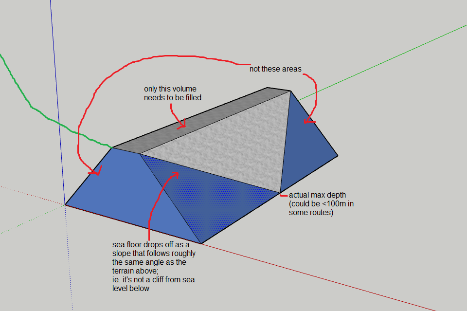
It would be the largest earth-fill project ever in the world.  Costing hundreds of billions.  But yes I guess it's possible.  Just not economically feasible.  The Three Gorges Dam moved 100 million cubic yards of earth.  This would require substantially more.  If the earth peninsula was only 20m wide from top to bottom (obviously it would actually have to be many times this as it goes from top to bottom) it would take 160 million cubic yards of earth and rock.


Same scale:


screenshot-www.google.com-2023.11.17-20_00_10.png


screenshot-www.google.com-2023.11.17-19_59_48.png


.


.


.


Three Gorges Dam is only 600 feet deep.  We have 750 here.


Three Gorges cost $25 billion.  It'll recover that cost in electricity sales in about 10 years.


Our project would cost at least $100 billion and tolls would barely even cover the annual maintenance costs.


Edited by Victoria Watcher, 17 November 2023 - 05:08 PM.


#2222 max.bravo

max.bravo
  • Member
  • 2,324 posts

Posted 17 November 2023 - 07:04 PM

Your math is way off. The inlet is 750’ deep at its MAX depth. Not the entire distance. And of course you wouldn’t choose the deepest crossing route to fill.

Here’s the same bathymetric chart I’ve posted here before.
https://www.research..._fig1_262874281

You could easily choose a route that’s fully within the 100-200m contour line.

Given that the depth drops at an angle (like a triangle, not a square) and the max depth is < 600ft at the apex point only, you’ve overcalculated fill needed by at least 2x.

Not to mention Three Gorges dam trucked that fill OUT of a hole. Mucho energy costs to scoop and remove against gravity.

I’m suggesting we are blasting at the top of a mountain and pushing rocks DOWN a hill

Edited by max.bravo, 17 November 2023 - 07:06 PM.


#2223 Victoria Watcher

Victoria Watcher

    Old White Man On A Canadian Island

  • Member
  • 55,558 posts

Posted 17 November 2023 - 07:09 PM

My simple math considers a wall 20m thick from top to bottom.   But in fact the bottom would have to be at least 300m wide, since the rock triangle is over 200m tall.  


So I've wildly underestimated it, since also a 20m wide road at the top will never work either.  Vehicle lanes will have to be at least 4.5m wide plus solid divider plus shoulders.  So 30m wide maybe?


4998.jpg


Edited by Victoria Watcher, 17 November 2023 - 07:27 PM.


#2224 Victoria Watcher

Victoria Watcher

    Old White Man On A Canadian Island

  • Member
  • 55,558 posts

Posted 17 November 2023 - 07:19 PM

Your math is way off. The inlet is 750’ deep at its MAX depth. Not the entire distance. And of course you wouldn’t choose the deepest crossing route to fill.

Here’s the same bathymetric chart I’ve posted here before.
https://www.research..._fig1_262874281

You could easily choose a route that’s fully within the 100-200m contour line.

Given that the depth drops at an angle (like a triangle, not a square) and the max depth is < 600ft at the apex point only, you’ve overcalculated fill needed by at least 2x.

Not to mention Three Gorges dam trucked that fill OUT of a hole. Mucho energy costs to scoop and remove against gravity.

I’m suggesting we are blasting at the top of a mountain and pushing rocks DOWN a hill


If we eliminate the Malahat by dumping it into the water, we have eliminated the need for a second route.


#2225 max.bravo

max.bravo
  • Member
  • 2,324 posts

Posted 17 November 2023 - 08:13 PM

I think you're conceptualizing the wrong shape. And consequently you've overshot the volume by about 2x more than is needed. You can shave 2/3 off your volume if you realize the underwater portion of the mountain doesn't drop off as a cliff from sea level below. It descends on an angle, and only the very bottom is the maximum depth. 


Attached Images

  • Capture.PNG


#2226 Victoria Watcher

Victoria Watcher

    Old White Man On A Canadian Island

  • Member
  • 55,558 posts

Posted 17 November 2023 - 08:18 PM

I agree. But my original calculation only accounted for a 20m wide rock wall from surface to bottom. And it’s obviously many, many times thicker than that.

Edited by Victoria Watcher, 17 November 2023 - 08:19 PM.


#2227 Lashlarue

Lashlarue
  • Member
  • 43 posts

Posted 01 December 2023 - 09:50 AM

‘People travelling the Trans-Canada Highway through the Kicking Horse Canyon are now using a wider, safer, four-lane divided highway, with the opening of the new westbound lanes through Phase 4 of the project.

Three phases of work have previously transformed 21 kilometres of narrow, winding two-lane highway into a modern four-lane, 100 km/h standard. Major construction of the fourth and final phase to complete the remaining – and most difficult – 4.8 kilometres began in early 2021.‘

https://thenelsondai...g-horse-canyon/

^jealous

Attached Images

  • IMG_5014.jpeg


#2228 max.bravo

max.bravo
  • Member
  • 2,324 posts

Posted 01 December 2023 - 09:56 AM

That looks insane
  • Nparker likes this

#2229 Nparker

Nparker
  • Member
  • 42,024 posts

Posted 01 December 2023 - 09:58 AM

That cantilevered section makes me nervous.


  • LJ likes this

#2230 lanforod

lanforod
  • Member
  • 11,718 posts
  • LocationSaanich

Posted 01 December 2023 - 12:08 PM

So many people have died on that stretch of highway; I suspect it makes the Malahat look like nothing.


#2231 Victoria Watcher

Victoria Watcher

    Old White Man On A Canadian Island

  • Member
  • 55,558 posts

Posted 01 December 2023 - 12:20 PM

So many people have died on that stretch of highway; I suspect it makes the Malahat look like nothing.


Kicking Horse Canyon has long been considered one of Canada’s most dangerous highway stretches. Between 1996 and 2001, 700 accidents on the winding road caused 21 deaths. From 1991 to 2000, almost 400 people were injured. For years, the accident rate on that stretch was double the provincial average.

https://www.timescol...g-tamed-5694873

Edited by Victoria Watcher, 01 December 2023 - 12:20 PM.


#2232 Mike K.

Mike K.
  • Administrator
  • 85,012 posts

Posted 01 December 2023 - 12:43 PM

Kicking Horse enters the 1970s!

This is what the Malahat should be like. 100km/h, full freeway through to Campbell River. There is nowhere else in North America with standards as low as on Vancouver Island.
  • FogPub and max.bravo like this

Know it all.
Citified.ca is Victoria's most comprehensive research resource for new-build homes and commercial spaces.


#2233 Nparker

Nparker
  • Member
  • 42,024 posts

Posted 01 December 2023 - 01:44 PM

...There is nowhere else in North America with standards as low as on Vancouver Island.

Vancouver Island has the same standards when it comes to elections.


#2234 lanforod

lanforod
  • Member
  • 11,718 posts
  • LocationSaanich

Posted 01 December 2023 - 01:49 PM

That picture is scary. It looks like one rockslide away from just washing away billions of dollars of work. (600m actually, but start now its probably >1b).


Edited by lanforod, 01 December 2023 - 01:50 PM.


#2235 Mike K.

Mike K.
  • Administrator
  • 85,012 posts

Posted 01 December 2023 - 02:42 PM

Oh I dunno, that steel looks to be 15 feet thick. It should fare well.


Know it all.
Citified.ca is Victoria's most comprehensive research resource for new-build homes and commercial spaces.


#2236 max.bravo

max.bravo
  • Member
  • 2,324 posts

Posted 01 December 2023 - 03:06 PM

It's not the steel that worries me, it's the concrete piers that look to be in the perfect location to be hit by falling boulders.


Not to mention the pier base looks to be located on a slope that experiences frequent rockslides... let's hope it's anchored very, very deep into that mountainside... 


Of course, I'm sure they did all the engineering and it's perfectly safe. It's just a scary looking photo. 


#2237 lanforod

lanforod
  • Member
  • 11,718 posts
  • LocationSaanich

Posted 01 December 2023 - 04:15 PM

I'm sure they did all the engineering on the Malahat so it wouldn't wash out too, right? 
 

Oh wait...


There's no accounting for the power of mother nature.


Edited by lanforod, 01 December 2023 - 04:15 PM.


#2238 LJ

LJ
  • Member
  • 13,008 posts

Posted 02 December 2023 - 05:36 AM

Why wouldn't they just blast out more of the rock face and build the highway on solid rock? You won't see it driving on it, but those cantilevered sections look scary to me.


Life's a journey......so roll down the window and enjoy the breeze.

#2239 Mike K.

Mike K.
  • Administrator
  • 85,012 posts

Posted 02 December 2023 - 07:51 AM

It should be scary! You’re traversing one of the craziest mountain ranges in the world!

Know it all.
Citified.ca is Victoria's most comprehensive research resource for new-build homes and commercial spaces.


#2240 Victoria Watcher

Victoria Watcher

    Old White Man On A Canadian Island

  • Member
  • 55,558 posts

Posted 10 March 2024 - 04:23 AM

$162M highway project through Goldstream park faces objections from First Nations


$162-million plan for 2.6 kilometres of the Malahat corridor within Goldstream Provincial Park was reaffirmed in last month’s provincial budget.


The $162-million plan to design and build safety and environmental improvements to 2.6 kilometres of the Malahat corridor within Goldstream Provincial Park was reaffirmed in last month’s provincial budget. It was originally announced in 2018 and about $15 million in engineering work and plans have been completed.
 

The work includes rock cuts and a section that brings highway retaining walls hard against the river and cantilevered extensions that hang over the waterway.


A public engagement period ended in 2020.


https://www.timescol...nations-8423211


The ministry’s most recent traffic data from 2019 shows that in the summer months just over 29,000 vehicles travel Highway 1 through Goldstream Park area every day.


From 2013 to 2017, 45 collisions occurred in the 1.7-kilometre stretch through the park and typical highway closures ranged from 30 minutes to two hours.


About 60% of the Malahat corridor is divided with concrete centre medians. The remaining open areas include Goldstream (1.5 kilomtetres) and the Summit to Bamberton (four kilometres).


Edited by Victoria Watcher, 10 March 2024 - 04:24 AM.


You're not quite at the end of this discussion topic!

Use the page links at the lower-left to go to the next page to read additional posts.


1 user(s) are reading this topic

0 members, 1 guests, 0 anonymous users