Jump to content


Photo

Cowichan Valley news, issues


  • Please log in to reply
59 replies to this topic

#41 Victoria Watcher

Victoria Watcher

    Old White Man On A Canadian Island

  • Member
  • 53,054 posts

Posted 23 March 2024 - 10:49 PM

OK, I have done more research.


I'll make this as simple as I can.


weirs.jpg


The new weir will reduce or maybe even eliminate the uncontrolled "high river flows" of winter.  TOP LEFT:  River Flows Are High


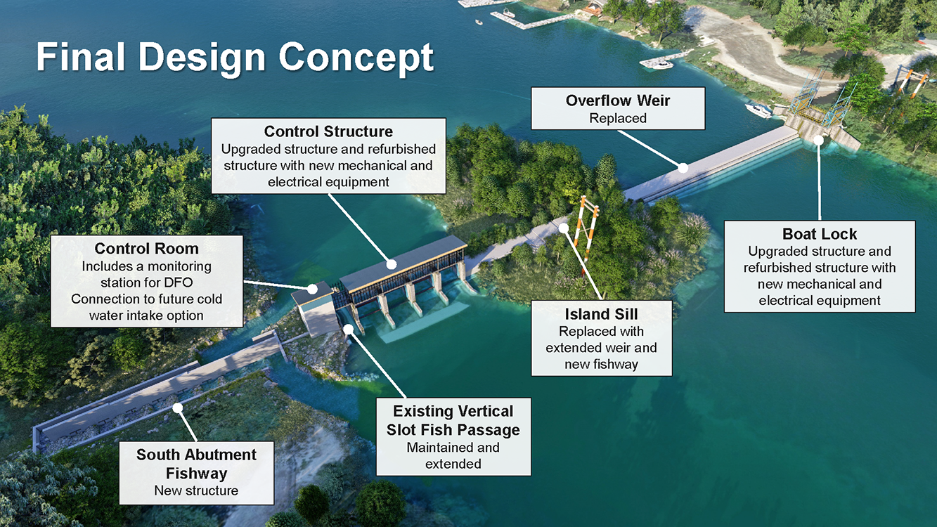
https://cowichanlake...ca/weir-design/


So all of those diagrams above show the old weir, except the one top left, where I added the new weir.


Now, you might say "surely the condition shown above for winter only exists for short periods, until the lake spills enough water to get back down to the top of the weir".  But that's not the case. In the winter, there is a near continual filling of the lake from rain and snow and other sources.  It just keeps coming!  Consider for a moment Niagara Falls.   That water simpy never stops coming, 365 days per year, there is always water added upstream.  Same thing in winter at Cowichan.


So as shown in the diagram top left, the new weir is incapable of holding the water level any (much?) higher than the average high water mark today.


I think.


5555555.jpg


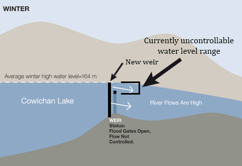
^ the old weir has problems with management in that entire range of lake level indicated there.  And that's a LOT of lake volume it can't control.  The new weir takes control of all that volume.


Cowichan Lake has a surface area of about 62 square kilometres.  I do not know how to work with big numbers, but that extra 70cm of weir height x 62 square kilometres is LOTS of water.  And remember, the river only requires about 4 cubic metres of water per second, at the very minimum.


Edited by Victoria Watcher, 23 March 2024 - 11:18 PM.


#42 Victoria Watcher

Victoria Watcher

    Old White Man On A Canadian Island

  • Member
  • 53,054 posts

Posted 23 March 2024 - 11:22 PM

The river only requires about 4 cubic metres of water per second, at the very minimum.


However, these are some of the targets:


March and April:  25 cubic m per second

May to June 15:  15

June 15 until fall rain:  7


Edited by Victoria Watcher, 23 March 2024 - 11:23 PM.


#43 Victoria Watcher

Victoria Watcher

    Old White Man On A Canadian Island

  • Member
  • 53,054 posts

Posted 24 March 2024 - 02:32 AM

Here is an interesting point:


Built in 1957, measuring 1 meter tall, it is located at the south end of Cowichan Lake. It is only operational, holding water back during the dry season (spring/summer/fall) when the lake is lower. During the winter, the gates are fully open and the water flows over the top. The “control point” that determines the height of the lake during the winter, is a natural narrowing/constricting of the river at Greendale trestle, downstream of the weir. So much of the time, from late fall until spring each year, the weir is referred to as “off control” – since the lake level is above the top of the weir having no effect on flow levels.


https://www.onecowic..._raise_the_weir


Related facts

The average maximum height the lake has reached over the years is 164.0 m. during the winter months.
The top of the weir is 162.37 m. Below this level, the discharge rate from the lake is under human control.
Zero storage is 161.4 m. At this level, control of the river shifts downstream to the natural river narrowing.
161.3 m. is the absolute lowest level at which 4.5 m3/s can be maintained. This is the lowest level at which fish and human needs can be marginally met. Raising the weir 30 cm. was previously found to achieve this flow in the 2007 report but with continued climate change and drought trends since then, the actual number needed to meet ecological, cultural, recreational, industrial and municipal requirements is still to be determined.

Edited by Victoria Watcher, 24 March 2024 - 02:35 AM.

  • max.bravo likes this

#44 Victoria Watcher

Victoria Watcher

    Old White Man On A Canadian Island

  • Member
  • 53,054 posts

Posted 24 March 2024 - 03:27 AM

The “control point” that determines the height of the lake during the winter, is a natural narrowing/constricting of the river at Greendale trestle, downstream of the weir. 


screenshot-www.google.com-2024.03.24-07_25_07.png


#45 Victoria Watcher

Victoria Watcher

    Old White Man On A Canadian Island

  • Member
  • 53,054 posts

Posted 24 March 2024 - 05:15 AM

Current:


catalyst-weir.jpg


Weir-Ready-picture.jpg


Proposal (first image is with optional (future?) walking path):


cowichan-lake-weir-rise-188081.jpg


cowichan_lake_weir_final_design_concept_sm.png


Edited by Victoria Watcher, 24 March 2024 - 05:18 AM.


#46 Victoria Watcher

Victoria Watcher

    Old White Man On A Canadian Island

  • Member
  • 53,054 posts

Posted 24 March 2024 - 07:35 AM

The Crofton pulp and paper mill, owned by Catalyst Paper, is the single largest user of water from the Cowichan River. Water is diverted from a pump station just west of Duncan, to Crofton. Catalyst's water permit allows the company to take up to 2.832 cubic metres per second (m3/s) – 89.3 million m3 per year.


screenshot-www.google.com-2024.03.24-11_34_00.png


 Catalyst Paper withdraws water from the Cowichan River for delivery to the Pulp and Paper Mill, and the community of Crofton. Water is withdrawn about a kilometer upstream of the Allenby Road bridge in Duncan. 


#47 Victoria Watcher

Victoria Watcher

    Old White Man On A Canadian Island

  • Member
  • 53,054 posts

Posted 24 March 2024 - 11:22 AM

^^ That doesn’t make any sense unless the lake water has a hill.


Here is a question. Say the lake is full and just pretend for a moment it has no water entering anywhere. If you go to the very far end away from the weir, and dump in 10 litres, how soon does water spill at the weir? Not that exact water, but any water.

#48 splashflash

splashflash
  • Member
  • 245 posts

Posted 24 March 2024 - 06:48 PM

The Crofton pulp and paper mill, owned by Catalyst Paper, is the single largest user of water from the Cowichan River. Water is diverted from a pump station just west of Duncan, to Crofton. Catalyst's water permit allows the company to take up to 2.832 cubic metres per second (m[/size]3/s) – 89.3 million m[/size]3 per year.[/size]

attachicon.gif screenshot-www.google.com-2024.03.24-11_34_00.png

[/size]Catalyst Paper withdraws water from the Cowichan River for delivery to the Pulp and Paper Mill, and the community of Crofton. Water is withdrawn about a kilometer upstream of the Allenby Road bridge in Duncan. [/size]

Catalyst Paper has closed until further notice. https://www.cbc.ca/n...-mill-1.7095393

The announcement comes just over a year after the mill, located in Crofton in the North Cowichan region, received $18.8 million from the provincial and federal governments to resume pulp and paper operations.

Approximately 75 employees are affected.

Edited by splashflash, 24 March 2024 - 06:57 PM.


#49 max.bravo

max.bravo
  • Member
  • 1,938 posts

Posted 24 March 2024 - 07:10 PM

Thanks for those posts VW. Very informative.

And^ it sounds like crofton home values just went up. The stinky mill is the only reason I wouldn’t live there. Nice little community otherwise.
  • Matt R. likes this

#50 Nparker

Nparker
  • Member
  • 40,775 posts

Posted 24 March 2024 - 07:25 PM

A nice little community that appears to have just lost a significant employer...


#51 dasmo

dasmo

    Grand Master ✔

  • Member
  • 15,499 posts

Posted 24 March 2024 - 09:32 PM

That’s OK. Real estate is our economy now….

#52 Matt R.

Matt R.

    Randy Diamond

  • Member
  • 8,047 posts

Posted 24 March 2024 - 10:11 PM

Just take the ferry to salt spring to work like the rest of Crofton does.

#53 Victoria Watcher

Victoria Watcher

    Old White Man On A Canadian Island

  • Member
  • 53,054 posts

Posted 24 March 2024 - 10:25 PM

Catalyst Paper has closed until further notice. https://www.cbc.ca/n...-mill-1.7095393

The announcement comes just over a year after the mill, located in Crofton in the North Cowichan region, received $18.8 million from the provincial and federal governments to resume pulp and paper operations.

Approximately 75 employees are affected.


Paper Excellence says its pulp operations, which employ 400 people, will continue production during the indefinite paper production curtailment.


#54 Sparky

Sparky

    GET OFF MY LAWN

  • Moderator
  • 13,149 posts

Posted 25 March 2024 - 05:29 AM

Ok this is starting to make more sense to me now after visiting the site. The high water level during the rainy season is not a result of the existing weir but is a result of the natural restraint of the Cowichan River downstream of the existing weir.


As you can see by this photo the lake is higher than the weir currently.


Weir 2.JPG


The natural high water level can be assumed that it is around the level of the discolouring on the marker. It can be assumed that the water between the top of the existing weir and the high water level is the water that they want to save for the dry season that will help keep the river flowing during the dry season.


Weir 1.JPG


Here is a shot below the weir that shows the water that is currently flowing over the existing weir that could be saved until the dry season.


Weir 3.JPG


Here is a shot of the natural restraint that the river bends provide that raises the water above the existing weir during the rainy season.


All this information matches and verifies the work that you did above VW and posted when I was up taking pictures. Thanks for that.


Weir 4.JPG


Here is an interesting tool that I found on the web that contains data on individual properties that front onto the lake. By zooming in on the interactive map and clicking on the arrows and then the "here" hyperlink, one can view the impact that the proposed new weir would have on any particular property. This interactive map must have been a ton of work to compile.


https://kwl.maps.arc...4d89629a4c0513b


#55 Victoria Watcher

Victoria Watcher

    Old White Man On A Canadian Island

  • Member
  • 53,054 posts

Posted 25 March 2024 - 05:35 AM

Good work!

#56 Nparker

Nparker
  • Member
  • 40,775 posts

Posted 25 March 2024 - 06:28 AM

Weir would we be without you Sparky?
  • Matt R., lanforod and max.bravo like this

#57 Mike K.

Mike K.
  • Administrator
  • 83,560 posts

Posted 25 March 2024 - 06:37 AM

Great work, Sparky!

Know it all.
Citified.ca is Victoria's most comprehensive research resource for new-build homes and commercial spaces.


#58 lanforod

lanforod
  • Member
  • 11,348 posts
  • LocationSaanich

Posted 25 March 2024 - 09:37 AM


Here is a question. Say the lake is full and just pretend for a moment it has no water entering anywhere. If you go to the very far end away from the weir, and dump in 10 litres, how soon does water spill at the weir? Not that exact water, but any water.


Probably not worth the thought exercise, but I'll let Copilot humour you:
 

When a lake is 100% full up to the top of a weir, and you add 10 liters of water at the opposite end of the lake from the weir (with no other water entering the system), we can calculate how long it would take for that additional water to flow over the weir.

Let’s break it down:

  1. The weir is a barrier across the width of the river or stream that alters the flow characteristics and changes the water level.
  2. We’ll assume the weir is a rectangular or triangular notch.
  3. The flow rate over the weir depends on the water depth above the weir.

To estimate the time it takes for 10 liters of water to flow over the weir, we need to consider the following:

  • The coefficient of discharge for the weir (which accounts for assumptions made in estimating flow rate).
  • The height of the water surface above the notch base.
  • The flow rate.

Since we’re dealing with a specific volume (10 liters), we can use the following steps:

  1. Measure the height of the water surface above the notch base (which will be the initial water level).
  2. Add the 10 liters of water to the lake.
  3. Observe the shape of the nappe (the flow of water over the weir).
  4. Calculate the flow rate based on the height and the weir characteristics.

Now, let’s apply this to our situation:

  • We have 10 liters of water.
  • We’ll measure the flow rate as the water flows over the weir.

Keep in mind that this calculation assumes ideal conditions and doesn’t account for factors like turbulence or other complexities. However, it provides a basic estimate.

If you’d like a more precise calculation, we can use the weir flow formulas and coefficients of discharge. Let me know if you’d like to explore that!

For more detailed information, you can refer to the Applied Fluid Mechanics Lab Manual and the FAO estimates of water flow.12


#59 Sparky

Sparky

    GET OFF MY LAWN

  • Moderator
  • 13,149 posts

Posted 25 March 2024 - 11:37 AM

^ Jesus...that was funny.


It's been a while since I have spent much time at Lake Cowichan, so yesterday's visit was a bit of a treat. We used to free camp on the north side way up past Youbou so we had to make our way up there and see if things had changes much.


This lake is HUGE!


I think if the water level was to rise 1/16" of an inch, that would mean like an extra gillion gallons of water.


C Lake.JPG


#60 Victoria Watcher

Victoria Watcher

    Old White Man On A Canadian Island

  • Member
  • 53,054 posts

Posted 25 March 2024 - 11:39 AM

Ya, it's a pretty impressive lake, I quite like it.


0 user(s) are reading this topic

0 members, 0 guests, 0 anonymous users