The bottom right hand corner shows the baseball diamond in BHP that VHF and I discussed in a thread a year or two ago.

Aerial Photos of BC from 1940's and 1950's
Started by
MarkP
, Apr 20 2012 08:35 AM
211 replies to this topic
#142

Bingo
-

- Member
- 16,666 posts
Posted 30 May 2012 - 05:38 AM
A completed Memorial Arena, and a still unfinished Christ Church Cathedral. The old Central High School is still there, as is the Empress Hotel laundry and St. Josephs Hospital. A large parking lot on the future site of the Provincial Museum, and many old houses on the sites of future government parking lots.
#143
Baro
-

- Member
- 4,317 posts
Posted 30 May 2012 - 06:24 AM
Does anyone have a map of how the tracks in front of value village went before they were ripped up?
"beats greezy have baked donut-dough"
#144
Bingo
-
- Member
- 16,666 posts
Posted 30 May 2012 - 04:40 PM
Does anyone have a map of how the tracks in front of value village went before they were ripped up?
No map but, the single track went down the middle of Store Street, and there was a siding behind the building the houses the Grindstone Cafe at Herald Street. You can still see the curve in the building that matched the curve in the tracks.
There was another siding and loading dock right up close to Value Village (formerly Kelly Douglas warehouse) minus those decorative beams that are there now.
#145
UrbanRail
-

- Member
- 2,114 posts
- LocationVictoria
Posted 30 May 2012 - 06:17 PM
Does anyone have a map of how the tracks in front of value village went before they were ripped up?
Here you go. http://forums.railfa...lbionaerial.jpg
Its an old aerial view dating from 1958
and a map of the approx. trackage layout
http://forums.railfa...1818747;start=0
#146
UrbanRail
-
- Member
- 2,114 posts
- LocationVictoria
Posted 30 May 2012 - 06:41 PM
Another in the same series, just North/East of the Johnson Street Bridge.
http://vintageairpho...com/bo-47-1456/
Mark
That is one cool shot of the Store St yards. I would be interested in purchasing a copy for my collection. I saw the prices, very reasonable and I am thinking of the printed option.
#147
Sparky
-

- Moderator
-

- 13,148 posts
GET OFF MY LAWN
Posted 30 May 2012 - 10:47 PM
The Lansdowne Airfield was abandoned in 1931, many years before the aerial photo was taken of Victoria.
more:
http://victoriahisto...downe-airfield/
Yes it was "officially" abandoned in 1931 but was still used for airshows after that. The hangar was not torn down until 1955. So that still could have been the airfield in the picture.
http://wpbradley.wor...com/2010/06/18/
#148
Bingo
-
- Member
- 16,666 posts
Posted 31 May 2012 - 07:04 AM
Yes it was "officially" abandoned in 1931 but was still used for airshows after that. The hangar was not torn down until 1955. So that still could have been the airfield in the picture.
http://wpbradley.wor...com/2010/06/18/
In the picture with the Tri-motors taken around 1928 the service was cancelled not long after, when one of the planes crashed into the sea on the way to Seattle.
#149
MarkP
-
- Member
- 31 posts
Posted 08 June 2012 - 10:31 PM
Hey guys, got a new one for ya. It from roughly Herald looking back toward the Empress. You get a better view of that end of town.
http://vintageairpho...com/bo-47-1451/
Mark
http://vintageairpho...com/bo-47-1451/
Mark
#150
Holden West
-

- Member
- 9,058 posts
Va va voom!
Posted 08 June 2012 - 10:48 PM
Wow, a very rare view from that angle. Look at the three tennis courts on Herald St. where the Chinatown apartment building is today.
"Beaver, ahoy!""The bridge is like a magnet, attracting both pedestrians and over 30,000 vehicles daily who enjoy the views of Victoria's harbour. The skyline may change, but "Big Blue" as some call it, will always be there."
-City of Victoria website, 2009
-City of Victoria website, 2009
#151
D.L.
-

- Member
- 7,786 posts
Posted 09 June 2012 - 03:48 AM
Gosh, look at that 10 story Bank of Toronto. I guess Victorians really did have something against those Toronto sized buildings.
#152
Bingo
-
- Member
- 16,666 posts
Posted 09 June 2012 - 06:14 AM
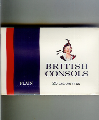
The Odeon Theatre is under construction.
That looks like a cigarette billboard ad at Douglas and Pembroke.
Could it be the lady for British Consols.
That looks like a cigarette billboard ad at Douglas and Pembroke.
Could it be the lady for British Consols.

#153
aastra
-

- Member
- 20,757 posts
Posted 09 June 2012 - 05:25 PM
Geez, look at that building on the southwest corner of Pandora and Government. Also, that one on the southeast corner of Broad and Pandora.
#154
Rick Pitts
-

- Member
- 2 posts
Posted 11 June 2012 - 04:57 PM
I sure would like to see the photo of that Kings Rd/ Douglas St. corner. When I was a kid my grandfather had a plumbing shop called Empire Plumbing and Heating next door to Pharmacy on the corner. He used to take care of the boiler in that building in the 50's......gawd I'm old.
#155
HB
-

- Banned
- 7,975 posts
Posted 11 June 2012 - 05:21 PM
Blanshard Street ends at Pandora in this photo.
#156
aastra
-
- Member
- 20,757 posts
Posted 11 June 2012 - 07:42 PM
The old annex/breezeway at Oaklands School was demolished a few years ago but it hasn't even been built yet in that 1947 picture.
I was way out to lunch when I said this. The annex with the pillars was definitely there in 1947. You can see it in the picture, behind the large trees.
#157
Bingo
-
- Member
- 16,666 posts
Posted 11 June 2012 - 08:35 PM
I was way out to lunch when I said this. The annex with the pillars was definitely there in 1947. You can see it in the picture, behind the large trees.
Which photo are we talking about?
#158
Langford Rat
-

- Member
- 405 posts
Posted 12 June 2012 - 08:10 PM
Bingo, I'm pretty sure that is her. The MacDonalds Lassie. She was (is) an iconic Canadian trademark for British Consol and Export "A" (the green death) brand cigarettes. She was created by one of Canada's most famous illustrators, Rex Woods, in the mid-thirties.
#159
MarkP
-
- Member
- 31 posts
Posted 14 June 2012 - 07:27 PM
Got the Burnside area of Victoria from 1951...
This is another cool one with lots of detail.
http://vintageairphotos.com/1-69/
Mark
This is another cool one with lots of detail.
http://vintageairphotos.com/1-69/
Mark
#160
Sparky
-
- Moderator
-
- 13,148 posts
GET OFF MY LAWN
Posted 14 June 2012 - 08:04 PM
Holy crap Mark, that one is excellent. I love the shot of the roundabout, the JSB, Point Ellis Bridge, RAP.
You can count the pieces of wood stacked at the mill.
I think I see the beginnings of the Monterey Restaurant.
Thank you for that.....this one is going to take some time to digest.
You can count the pieces of wood stacked at the mill.
I think I see the beginnings of the Monterey Restaurant.
Thank you for that.....this one is going to take some time to digest.
You're not quite at the end of this discussion topic!
Use the page links at the lower-left to go to the next page to read additional posts.
Use the page links at the lower-left to go to the next page to read additional posts.


0 user(s) are reading this topic
0 members, 0 guests, 0 anonymous users

