I did from 1914. See above.

Rising Sea Levels
Started by
Chef-eth
, May 08 2015 06:45 AM
1715 replies to this topic
#1521

dasmo
-

- Member
- 19,229 posts
Grand Master ✔
- LocationThe Pearly Gates
Posted 09 July 2024 - 12:32 PM
#1522
dasmo
-
- Member
- 19,229 posts
Grand Master ✔
- LocationThe Pearly Gates
Posted 09 July 2024 - 12:37 PM
Select number 5X space to see Victoria precipitation data from 1914.

#1523
dasmo
-
- Member
- 19,229 posts
Grand Master ✔
- LocationThe Pearly Gates
Posted 09 July 2024 - 12:40 PM
The left shows the first half of the century overlaid onto the latter half. Less rain the first half.... Also the overall trend is visible. event the last peak to peak would probably still smooth out to show a gradual increase in real from 1914. Download the data and load it into excel to play around with it. That would be the way to prove me wrong with my quick visuals.
One thing is certain, there is not alarming downtrend.
#1524
Tony
-

- Member
- 982 posts
Posted 10 July 2024 - 08:47 AM
I was responding to Mike with the information relating to 1914 start date.
Not trying to prove anyone right or wrong. Just sharing information sources and opinions.
Some questions.
Why is joining maximum peaks with up or down line slopes over a time proof of a clear trend.? Are these peaks not just examples of the extremes of the data? Does one not have to be careful in dealing with the extremes? What other statistical analysis of the data would perhaps be another way to try to revel trends if there are any in this data.
There seems to be lots of variation in the data.
Perhaps as previously indicated the time line is too short or there are no clear statistical trends.
#1525
Victoria Watcher
-

- Member
- 65,620 posts
Old White Man On A Canadian Island
Posted 12 July 2024 - 03:52 PM
The remnants of Hurricane Beryl have brought flash floods and destruction to parts of the Maritimes, but federal officials say the storm has also reduced the risk of wildfires in parts of Eastern Canada, at least for now.
Overall this wildfire season is far less severe than the record-setting year in 2023, but the risk for new fires is still high in particular for B.C., Yukon and Northwest Territories.
_____________________
The Canadian Interagency Forest Fire Centre reports 577 active fires as of Thursday, including 402 out of control. Federal officials say there is a response to try and douse the flames for about half the active fires.
The rest are being monitored but are too far away from communities or infrastructure to warrant a response at this time.
Just shy of 1.3 million hectares have burned, which is close to the 10-year average for this time of year. By contrast, 1.3 million hectares had burned in B.C. alone by mid-July of last year. Nationally by mid-July nearly 10 million hectares had already burned in 2023.
https://www.cheknews...months-1213852/
Despite current high risk, this year's wildfire season tracking close to normal, statistics show
Total hectares burned to mid-July is close to 10-year average
https://www.cbc.ca/n...-show-1.7262219
Edited by Victoria Watcher, 12 July 2024 - 03:56 PM.
#1526
Nparker
-

- Member
- 42,889 posts
Posted 12 July 2024 - 04:07 PM
My cruise deftly sailed around Hurricane Beryl last week. We only had about half a day of slightly drizzly weather.
- Victoria Watcher likes this
#1527
Mike K.
-

- Administrator
-

- 90,814 posts
Posted 12 July 2024 - 04:15 PM
There’s now a human caused wildfire along the Adam River, north of Highway 19.
Know it all.
Citified.ca is Victoria's most comprehensive research resource for new-build homes and commercial spaces.
#1528
Victoria Watcher
-
- Member
- 65,620 posts
Old White Man On A Canadian Island
Posted 12 July 2024 - 10:04 PM
For at least a decade Quinault Nation has tried to escape the rising Pacific. Time is running out
https://apnews.com/a...5ec72fa07727478
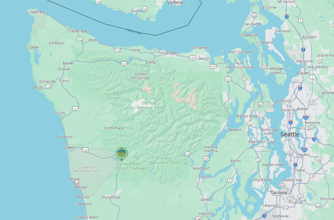
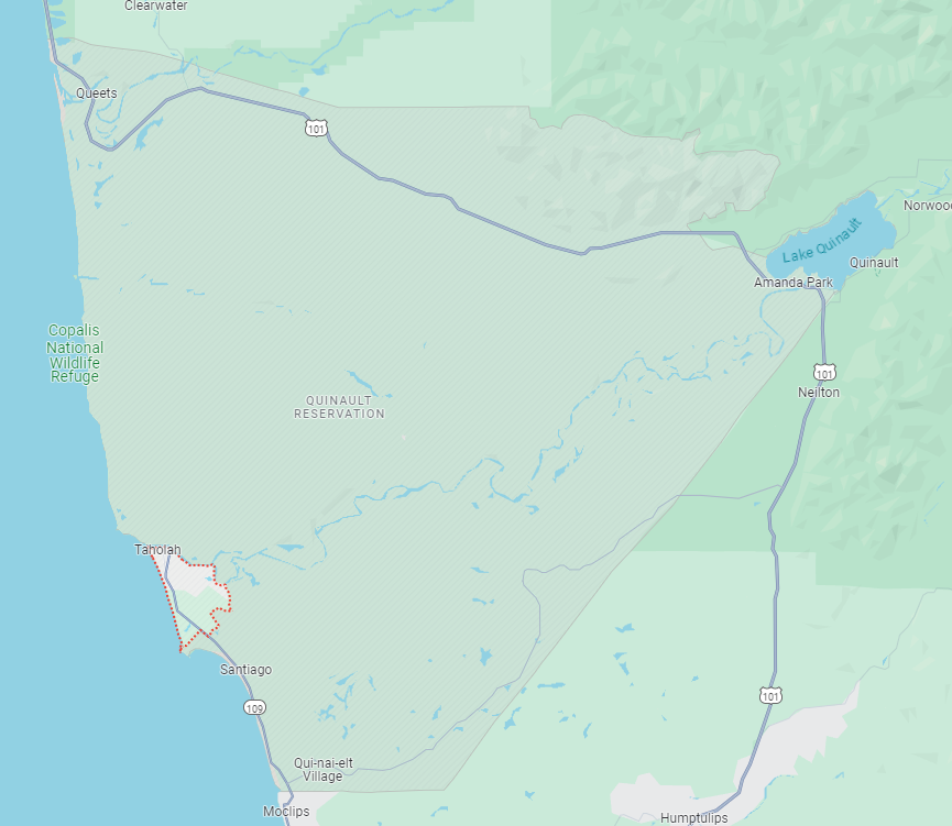
They have 220,000 acres. For 2,500 members (not clear how many live on reserve).
The Quinault Indian Nation owns Quinault Pride Seafood, Land, and Timber Enterprises, and the Mercantile in Taholah, Washington. They run their own internal facilities and in the 21st century are the largest employer in Grays Harbor County.[4]
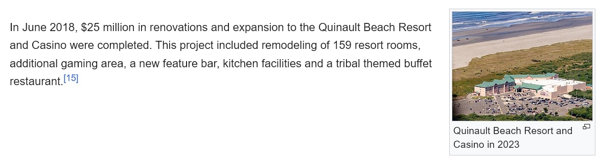
They also own and operate the Quinault Beach Resort and Casino, a new enterprise started in the late 20th century; Emily's Ocean Front Restaurant, Sidewalk Bistro and Deli, coffee bar, and Fireplace Nook; and Qmart 1 in Oyehut, near Ocean Shores, Washington. They also own Qmart 2 in Aberdeen.[14]
Since 2009, the casino has been the site of the annual Hog Wild Rally, one of the largest motorcycle rallies in the Pacific Northwest.[citation needed]
In June 2018, $25 million in renovations and expansion to the Quinault Beach Resort and Casino were completed. This project included remodeling of 159 resort rooms, additional gaming area, a new feature bar, kitchen facilities and a tribal themed buffet restaurant.
I think they might be fine.
And that mould behind the washing machine has little to do with rising sea levels.
#1529
Victoria Watcher
-
- Member
- 65,620 posts
Old White Man On A Canadian Island
Posted 19 July 2024 - 05:56 PM
- Nparker likes this
#1530
aastra
-

- Member
- 21,902 posts
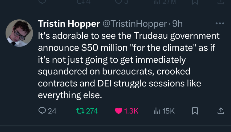
Posted 19 July 2024 - 10:33 PM
$50 million CAD will surely do great things. Meanwhile, the previous news item claimed it would cost $400+ million USD just to address the relocation of a few hundred members of the Quinault Nation.
Can I suggest there are some other severe inconsistencies in the narrative? On the one hand we claim we're pulling out all the stops to deal with this urgent existential issue, but on the other hand we're also investing tens of millions in waterfront casinos?
#1531
Victoria Watcher
-
- Member
- 65,620 posts
Old White Man On A Canadian Island
Posted 24 July 2024 - 06:04 AM
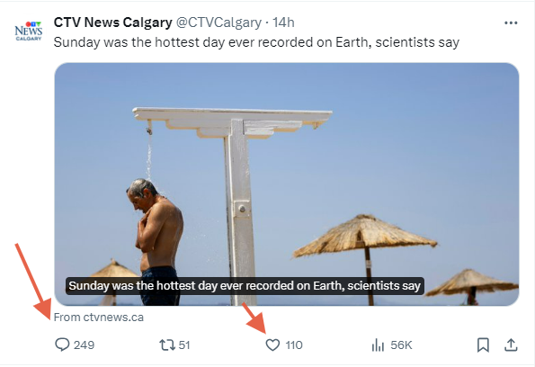
Sunday was the hottest day ever recorded, breaking global temperatures dating back to 1940, according to preliminary data from Europe's Copernicus Climate Change Service.
https://www.ctvnews....s-say-1.6975018
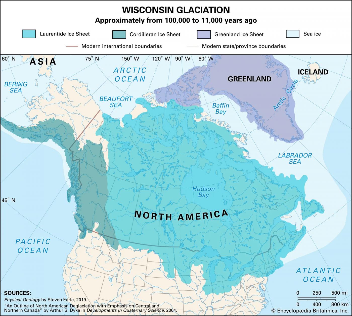
Presumably, the coldest day ever recorded on earth was sometime between 1940 and now. But 10,000 years ago ice covered most of BC/Canada.
Edited by Victoria Watcher, 24 July 2024 - 06:08 AM.
#1532
Victoria Watcher
-
- Member
- 65,620 posts
Old White Man On A Canadian Island
Posted 26 July 2024 - 05:21 AM
A researcher who looked into deaths during the eight hottest days of B.C.’s deadly heat dome says that equitably addressing the impacts of climate change would mean placing a larger focus on people living in poverty.
Sarah Henderson was part of a team with the B.C. Centre for Disease Control that compared about 1,500 people who died from a range of causes during the heat dome with similar people who survived, focusing on health conditions and socioeconomic status.
The study, published this week in Environmental Research: Health, found the risk factor most strongly associated with dying during those sweltering days in the summer of 2021 was whether that person was receiving income assistance.
https://www.cheknews...-study-1216043/
Pefect. The solution to reducing deaths during the heat domes is to maybe cut off social assistance once the temperature hits 25 degrees. Or to make it less complicated, just cut it off every summer. Now I'm not saying deprive these souls of their rightful assistance, but maybe cut it off for three summer months, and double it in 3 winter months. 
Edited by Victoria Watcher, 26 July 2024 - 05:22 AM.
#1533
Victoria Watcher
-
- Member
- 65,620 posts
Old White Man On A Canadian Island
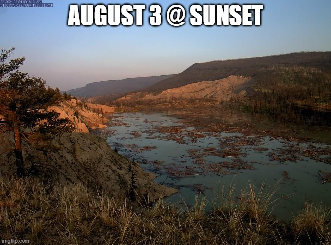
Posted 03 August 2024 - 01:16 PM
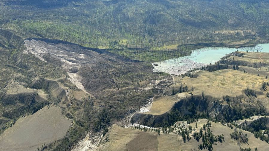
Officials outline 'worst-case' scenario for Chilcotin River flood
River flows are expected to be above peak spring levels along the Chilcotin River after Wednesday landslide
https://www.cbc.ca/n...tions-1.7284747
Can't they cut a path through this thing?
Maybe not.
And here come the keyboard commandos blaming government for not "doing something about it".
Dig it out! Use explosives! Meemaw and Peepaw could have had it done using their excavator! Simple math shows roughly 360000 cubic yards of material came down. That is the equivalent of 36000 gravel trucks. Better git at it!
https://forums.casta...c.php?p=3373116
Can we use a nuclear bomb? Or several.
Edited by Victoria Watcher, 03 August 2024 - 01:19 PM.
#1534
LJ
-

- Member
- 14,156 posts
Posted 03 August 2024 - 07:37 PM
Now they figure the water will just flow over the top of the slide, eventually cutting a path through it.
Life's a journey......so roll down the window and enjoy the breeze.
#1535
Victoria Watcher
-
- Member
- 65,620 posts
Old White Man On A Canadian Island
Posted 03 August 2024 - 07:41 PM
Water rise from Chilcotin River landslide may not be as high as feared: B.C. officials
https://globalnews.c...ate-aug-3-2024/
#1536
Sparky
-

- Moderator
-

- 13,731 posts
GET OFF MY LAWN
Posted 04 August 2024 - 04:27 AM
I had to look up "freshet".
#1537
Victoria Watcher
-
- Member
- 65,620 posts
Old White Man On A Canadian Island
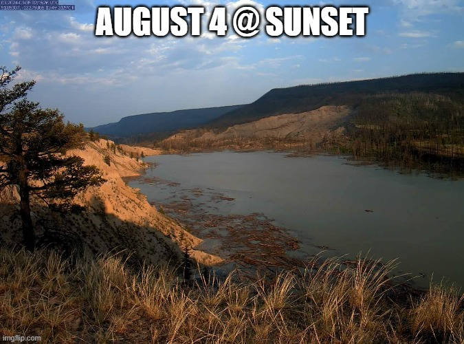
Posted 04 August 2024 - 04:55 PM
New modelling suggests water will start to move over overtop the landslide along the Chilcotin River Sunday (Aug. 4) or early on Monday.
In a news release Sunday afternoon, provincial authorities say in the best-case scenario, it is anticipated that it will take 12 to 24 hours for the trapped water to pass through the blockage. The scenario predicts flows below typical spring flooding peaks on the Fraser River but significantly higher than usual on the Chilcotin River. If the water moves through in 12 hours, the Chilcotin River could see peak flows over 10 times greater than a typical freshet peak. In the 24-hour scenario, peak flows could be over seven times greater.
https://fraservalley...landslide-soon/
I'm no hydrologist, but to me it looks like this might not be so bad.
Check the 3D panorama here:
https://chilcotin-ri...-panoramas#aug3
I think once it starts flowing over the blockage, as long as it does not erode a channel through the slide material too quickly and too deeply, it'll be somewhat controlled. At least based on the modelling I've been doing all weekend in my back yard sandbox.
Live webcam:

Edited by Victoria Watcher, 04 August 2024 - 05:07 PM.
- Mike K., phx and Matt R. like this
#1538
Victoria Watcher
-
- Member
- 65,620 posts
Old White Man On A Canadian Island
Posted 04 August 2024 - 09:20 PM
#1539
Victoria Watcher
-
- Member
- 65,620 posts
Old White Man On A Canadian Island
Posted 05 August 2024 - 06:35 AM
Still not over.
Over-top move of water at Chilcotin landslide site expected within hours, says government
British Columbia's emergency management ministry says water is expected to start moving over the top of the massive landslide site currently blocking the Chilcotin River within hours.
The ministry says in a statement area modelling suggests water is expected to start moving over the top of the landslide site late Sunday or early Monday and enter the riverbed below the slide area.
The statement says minimal seepage from the slide site is being observed, but the water level behind the dammed area continues to increase at about 18 centimetres per hour.
Edited by Victoria Watcher, 05 August 2024 - 06:36 AM.
#1540
Victoria Watcher
-
- Member
- 65,620 posts
Old White Man On A Canadian Island
Posted 05 August 2024 - 08:02 AM
As of 7 a.m. Monday, Aug. 5 the water is still there above the Chilcotin River landslide that blocked the river sometime between July 30 and 31.
Ken Ilnicki of Ilnicki Ranch where the slide is located was out checking the status of the slide first thing.
"It must be close," he said. "Just going to take a closer look."
When he got back he sent some photographs to Black Press Media.
"Maybe not even today," he texted.
On Sunday, Aug. 4, a provincial update suggested the water could begin overflowing the slide debris or natural dam at some point late Sunday or early Monday.
https://www.wltribun...g-aug-5-7471382
Edited by Victoria Watcher, 05 August 2024 - 08:02 AM.
You're not quite at the end of this discussion topic!
Use the page links at the lower-left to go to the next page to read additional posts.
Use the page links at the lower-left to go to the next page to read additional posts.


1 user(s) are reading this topic
0 members, 1 guests, 0 anonymous users

