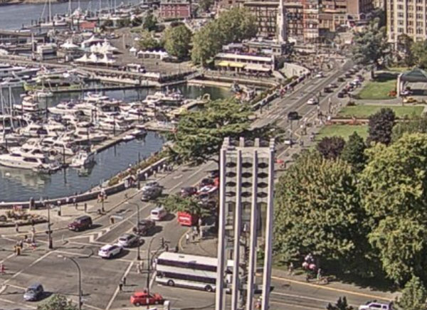
Government Street at Belleville looks like a hot mess right now. It's a two-to-three light cycle to get through Government at Humboldt.
You can watch live at https://royalbcmuseu...channel/web-cam


Posted 07 August 2019 - 03:41 PM
Government Street at Belleville looks like a hot mess right now. It's a two-to-three light cycle to get through Government at Humboldt.
You can watch live at https://royalbcmuseu...channel/web-cam
Know it all.
Citified.ca is Victoria's most comprehensive research resource for new-build homes and commercial spaces.

Posted 07 August 2019 - 03:51 PM
That's always been pretty standard for summertime around 4:30/5:00 pm. The combination of the government worker exodus for the day with the massive amount of tourists. Ever try crossing one of the non-traffic light intersections on Government in a car? (i.e. Government & Broughton) Even at night it sometimes takes a full minute of waiting for the onslaught of tourists to get across the crosswalk. As you can imagine, when you combine that with rush hour traffic, Government is insane. You have back-to-back crosswalks to contend with (Courtney and Broughton) immediately after Belleville if you're driving up Government. At the height of tourist season...I wish anyone driving up that road the best of luck in not killing anyone. Automatic backlog.

Posted 07 August 2019 - 03:54 PM
Government Street at Belleville looks like a hot mess right now. It's a two-to-three light cycle to get through Government at Humboldt.
You can watch live at https://royalbcmuseu...channel/web-cam
wharf.jpg

Posted 07 August 2019 - 04:02 PM
That's always been pretty standard for summertime around 4:30/5:00 pm. The combination of the government worker exodus for the day with the massive amount of tourists. Ever try crossing one of the non-traffic light intersections on Government in a car? (i.e. Government & Broughton) Even at night it sometimes takes a full minute of waiting for the onslaught of tourists to get across the crosswalk. As you can imagine, when you combine that with rush hour traffic, Government is insane. You have back-to-back crosswalks to contend with (Courtney and Broughton) immediately after Belleville if you're driving up Government. At the height of tourist season...I wish anyone driving up that road the best of luck in not killing anyone. Automatic backlog.
I've driven the corridor a lot during rush hour, and I've never seen cars butting out into the Belleville intersection that way we're seeing it now. Things have become much more congested.
Know it all.
Citified.ca is Victoria's most comprehensive research resource for new-build homes and commercial spaces.
Posted 07 August 2019 - 04:08 PM
I've driven the corridor a lot during rush hour, and I've never seen cars butting out into the Belleville intersection that way we're seeing it now. Things have become much more congested.
I also have anecdotal experience having driven that stretch many times at the 4:30 pm exodus, it is crazy, and has been for many years, with traffic often backed up to Belleville. Heck, go look at the webcam now and all is well.
That being said, there's also a massive new government office complex that has added a lot more people to the area that punch out at 4:30 pm. Maybe the bike lanes have a negligible impact here, but I would argue this has been a specific issue in this area for many years driven by the specific situation of end of the work day plus summer tourist season.
Edited by shoeflack, 07 August 2019 - 04:09 PM.

Posted 07 August 2019 - 04:12 PM
It's such a disaster that Gov't between Belleville & Humboldt now has 1 car in view. Yep, disaster.

Posted 07 August 2019 - 04:17 PM
I've driven the corridor a lot during rush hour, and I've never seen cars butting out into the Belleville intersection that way we're seeing it now. Things have become much more congested.
I don't drive a lot but I have been down there at this time last summer quite a bit and that looks about like what traffic was then too.

Posted 07 August 2019 - 05:29 PM

Posted 07 August 2019 - 07:38 PM
^ Scrambles were added to Banff Ave back in 2012 when I still lived there. There were previously advance right turns for vehicles, since the pedestrian volumes were so high that it was impossible to ever make a turn off of Banff Ave.
FWIW, Richmond has a scramble in Steveston, and Vancouver is getting a couple of them on Robson Street.
I was a bit confused about the Robson Street scramble intersections as if I recall, they were to be placed at two three-way intersections. There's no added benefit of being able to cut diagonally across the intersection at a three-way intersection.

Posted 07 August 2019 - 07:59 PM
I wonder if hindsight will say there ought to have been bike lanes on both sides of the new JSB (rather than just the north side), connected to each other on the Vic West side by keeping the old railway bridge over Esquimalt Rd. That way, a rider leaving town could access the bridge relatively safely from north, east, or south on the downtown side. Coming into downtown, a rider would figure out which side of the bridge to be on before crossing it, based on where next he-she was planning to go.
Posted 07 August 2019 - 08:09 PM
Know it all.
Citified.ca is Victoria's most comprehensive research resource for new-build homes and commercial spaces.

Posted 07 August 2019 - 08:17 PM
I wonder if hindsight will say there ought to have been bike lanes on both sides of the new JSB (rather than just the north side), connected to each other on the Vic West side by keeping the old railway bridge over Esquimalt Rd. That way, a rider leaving town could access the bridge relatively safely from north, east, or south on the downtown side. Coming into downtown, a rider would figure out which side of the bridge to be on before crossing it, based on where next he-she was planning to go.
For another $25M...no problem.

Posted 07 August 2019 - 08:47 PM
I mostly like the bike lanes and use them most days however the transition from Warf street bike lanes onto the bridge bike lane is very dangerous.
Today I rode the new lane, waited at the light for the slip road then continued when the bike lane had a green light. There is nothing to say a bike can't turn off the green bike lane onto the unpainted bridge bike lane so I did. The problem being the light is timed to set the cars going from Pandora street going at the same time. The cars coming from that side have yield signs however they mostly see the green lights that are 15 feet further on ( for the bridge deck being up or down) and blow past the signs. A lady was 1 foot from taking me out and seemed oblivious to anything.
Posted 08 August 2019 - 07:33 AM
I wonder if hindsight will say there ought to have been bike lanes on both sides of the new JSB (rather than just the north side), connected to each other on the Vic West side by keeping the old railway bridge over Esquimalt Rd. That way, a rider leaving town could access the bridge relatively safely from north, east, or south on the downtown side. Coming into downtown, a rider would figure out which side of the bridge to be on before crossing it, based on where next he-she was planning to go.
Probably. The JSB is a very early-2000's design for bikes. Unprotected bike lanes and an unseparated path on the north side. In hindsight, it should have protected bike lanes on street, with a separated path on the north side for the trail.
Posted 08 August 2019 - 10:17 AM
Probably. The JSB is a very early-2000's design for bikes. Unprotected bike lanes and an unseparated path on the north side. In hindsight, it should have protected bike lanes on street, with a separated path on the north side for the trail.
I was hypothetically thinking more of having the trail split on the west side of the bridge and then having two separated crossings - the north-side one where it is now and the south-side one in place of - or augmenting - the pedestrian bridge, with no bike lanes on the street at all. (all bikes would be diverted to the trail crossings)
Thus, if you're biking from Esquimalt or the goose you'd make your decision ahead of time whether you want to end up on the Pandora path or the Wharf St path, and then use the appropriate bridge crossing.
But - pun intended - it's all water under the bridge now.

Posted 08 August 2019 - 03:31 PM
For another $25M...no problem.
For another $50M, you mean.

Posted 09 August 2019 - 11:24 AM
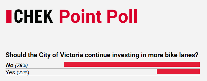
Additional investment in bike lanes wasn't a big winner in yesterday's CHEK Point Poll.

Posted 09 August 2019 - 12:58 PM
Posted 09 August 2019 - 01:02 PM
Now it would be interesting to get a poll of just the people who live in victoria proper
An actually scientifically conducted poll in 2016 found the exact opposite: https://drive.google...VJlzJbNvB_/view
Posted 09 August 2019 - 02:02 PM
Now it would be interesting to get a poll of just the people who live in victoria proper
Why does it matter where they live as long as they're regularly in Victoria? If tomorrow Saanich decides to ban cycling on any path pedestrians might be on or decides to dig up the bike lanes and not allow bikes anywhere they would impede the flow of traffic are cyclists from Victoria not allowed to express dissatisfaction no matter how often they're in Saanich because they live on the wrong side of Tolmie?


0 members, 1 guests, 0 anonymous users

Community Forum Software by IP.Board 3.4.6
Licensed to: Citified Media Inc. All materials © Copyright Citified Media Inc. All rights reserved.
