Jump to content


Photo

Westshore Parkway


  • Please log in to reply
94 replies to this topic

#61 exc911ence

exc911ence
  • Member
  • 757 posts

Posted 04 October 2017 - 07:50 AM

What does that mean?


It means that there will still only be one road... it'll just be a new one. Typical backwater thinking.


If I lived on Humpback and was forced to drive the "great circle route" to my house from Hwy 1 because of this closure, I'd be pissed.


#62 VicHockeyFan

VicHockeyFan
  • Suspended User
  • 52,121 posts

Posted 04 October 2017 - 07:53 AM

So they will dead-end Humpback on with side of the tracks?  Some people will like the idea of reduced traffic.


<p><span style="font-size:12px;"><em><span style="color:rgb(40,40,40);font-family:helvetica, arial, sans-serif;">"I don’t need a middle person in my pizza slice transaction" <strong>- zoomer, April 17, 2018</strong></span></em></span>

#63 malahatdrive

malahatdrive
  • Member
  • 186 posts

Posted 04 October 2017 - 07:56 AM

So they will dead-end Humpback on with side of the tracks?  Some people will like the idea of reduced traffic.

Humpback Rd will be dead-ended at the tracks both sides. However on the west side - Humpback road connects to Irwin Road which has been extended and connects to West Shore Parkway.


#64 VicHockeyFan

VicHockeyFan
  • Suspended User
  • 52,121 posts

Posted 04 October 2017 - 07:59 AM

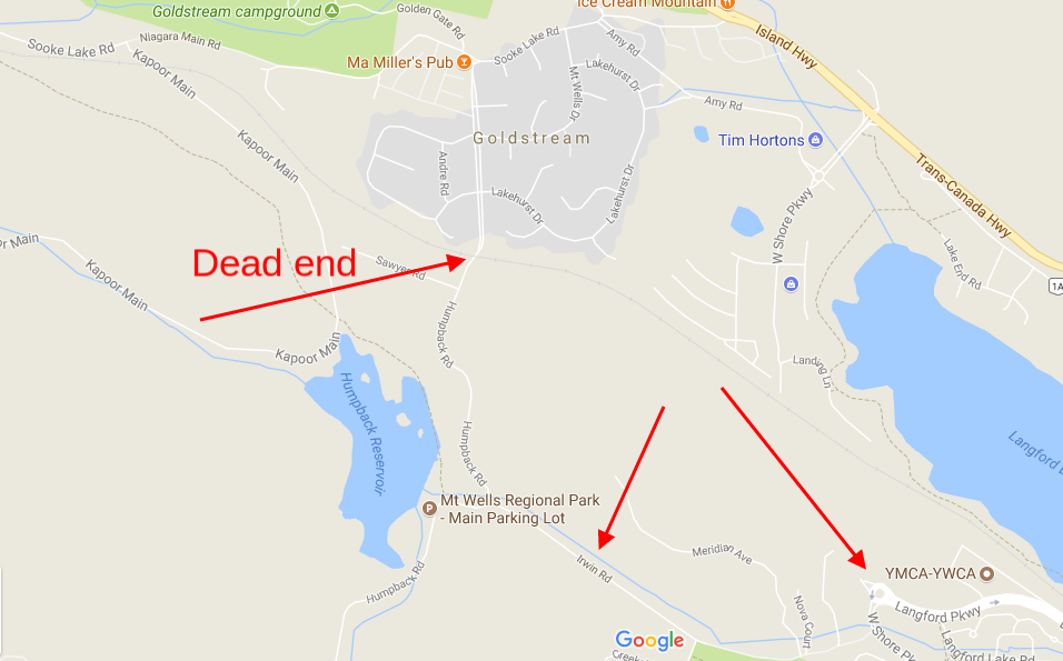
Humpback Rd will be dead-ended at the tracks both sides. However on the west side - Humpback road connects to Irwin Road which has been extended and connects to West Shore Parkway.


Ah, OK.  So here it is:


screenshot-www.google.ca-2017-10-04-08-58-12-720.png


<p><span style="font-size:12px;"><em><span style="color:rgb(40,40,40);font-family:helvetica, arial, sans-serif;">"I don’t need a middle person in my pizza slice transaction" <strong>- zoomer, April 17, 2018</strong></span></em></span>

#65 VicHockeyFan

VicHockeyFan
  • Suspended User
  • 52,121 posts

Posted 04 October 2017 - 08:02 AM

Humpback Rd. is quite something there through the Cressida subdivision.  It's a divided road with trees down the centre.  Not sure how it got that design.


screenshot-www.google.ca-2017-10-04-09-03-49-868.png


Edited by VicHockeyFan, 04 October 2017 - 08:04 AM.

<p><span style="font-size:12px;"><em><span style="color:rgb(40,40,40);font-family:helvetica, arial, sans-serif;">"I don’t need a middle person in my pizza slice transaction" <strong>- zoomer, April 17, 2018</strong></span></em></span>

#66 Cassidy

Cassidy
  • Banned
  • 2,501 posts
  • LocationVictoria

Posted 04 October 2017 - 08:08 AM

That totally sucks.

Humpback Road was part of my favorite "Southern cross Island" Sunday drive.


Starting at Silver Spray - East Sooke Rd to Gillespie Rd to Sooke Rd to Humpback Rd to Hwy #1 into Goldstream Park, and on up Finlayson Arm Rd to Millstream Rd to Munn Rd to Prospect Lake Rd  thru to Sparton Rd, then onto Oldfield Rd to Keating to Island View Rd and on down to the beach.


I love that drive, and the stunning forest drive through Humpback to Goldstream village is a huge part of it.

I don't want to do that part of my favorite drive on a "new highway" ... not that a local government (Langford) sucking up to a bunch of hikers and greenies (Island Corridor) cares :)


#67 VicHockeyFan

VicHockeyFan
  • Suspended User
  • 52,121 posts

Posted 04 October 2017 - 08:12 AM

I used to like Humpback when I was a road salesman and out in West Shore 4 days a week. 


<p><span style="font-size:12px;"><em><span style="color:rgb(40,40,40);font-family:helvetica, arial, sans-serif;">"I don’t need a middle person in my pizza slice transaction" <strong>- zoomer, April 17, 2018</strong></span></em></span>

#68 Bingo

Bingo
  • Member
  • 16,666 posts

Posted 04 October 2017 - 02:07 PM

I used to like Humpback when I was a road salesman and out in West Shore 4 days a week. 


You sold roads???


#69 VicHockeyFan

VicHockeyFan
  • Suspended User
  • 52,121 posts

Posted 04 October 2017 - 02:15 PM

You sold roads???


I sold appliances to builders and new home buyers.  And 3 or 4 days of the week I was on the road to job sites.


47205387_614.jpg


<p><span style="font-size:12px;"><em><span style="color:rgb(40,40,40);font-family:helvetica, arial, sans-serif;">"I don’t need a middle person in my pizza slice transaction" <strong>- zoomer, April 17, 2018</strong></span></em></span>

#70 LJ

LJ
  • Member
  • 12,753 posts

Posted 04 October 2017 - 07:44 PM

So they will dead-end Humpback on with side of the tracks?  Some people will like the idea of reduced traffic.

You bet they will. The folks living on the NW end of Goldstream thought they had died and gone to heaven when that road was closed off to the TCH.

They went from a busy thoroughfare to a country lane overnight. 


Life's a journey......so roll down the window and enjoy the breeze.

#71 Mike K.

Mike K.
  • Administrator
  • 83,592 posts

Posted 15 October 2017 - 07:39 AM

The road’s been open for a month and a half, and the little extension to the TCH opened two weeks ago.

But you wouldn’t know it if you were planning your trip via Google Maps.

What’s the delay here? When roads close due to accidents that data is instantly reflected on Google Maps, but a major road connecting two highways is non-existent on Google Maps nearly two months after it opened to traffic.

Know it all.
Citified.ca is Victoria's most comprehensive research resource for new-build homes and commercial spaces.


#72 Cassidy

Cassidy
  • Banned
  • 2,501 posts
  • LocationVictoria

Posted 15 October 2017 - 07:47 AM

Google traffic conditions are updated in real time because Google analyzes the GPS data of everybody who's currently using Google Maps while they're driving. Google analyzes GPS data and vets it against the speed you should be traveling at, the speed your were traveling at, and the speed you're currently travelling at.


But updates to Google Maps aerials and street views are "manual", and sometimes more than a few years out of date.


I live on a pretty main thoroughfare in Saanich, and the street view of my house shows my mothers car in the driveway ... and she passed away five years ago.

Google also shows my house in the aerial photo as not having a shed in my backyard, and yet I build a shed four years ago.


Google is WAAAAAAYYYYY out of date on all but the very largest cities in North America.


(but it's rather draconian access to, and analysis of your personal GPS data ensures "real-time" traffic information!!)


  • Nparker likes this

#73 sebberry

sebberry

    Resident Housekeeper

  • Moderator
  • 21,511 posts
  • LocationVictoria

Posted 15 October 2017 - 07:52 AM

Google traffic conditions are updated in real time because Google analyzes the GPS data of everybody who's currently using Google Maps while they're driving. Google analyzes GPS data and vets it against the speed you should be traveling at, the speed your were traveling at, and the speed you're currently travelling at.


Marginally creepy.  I wonder if everyone hitting "I agree" when they opened up that fancy new hone knew all their travels were being tracked.


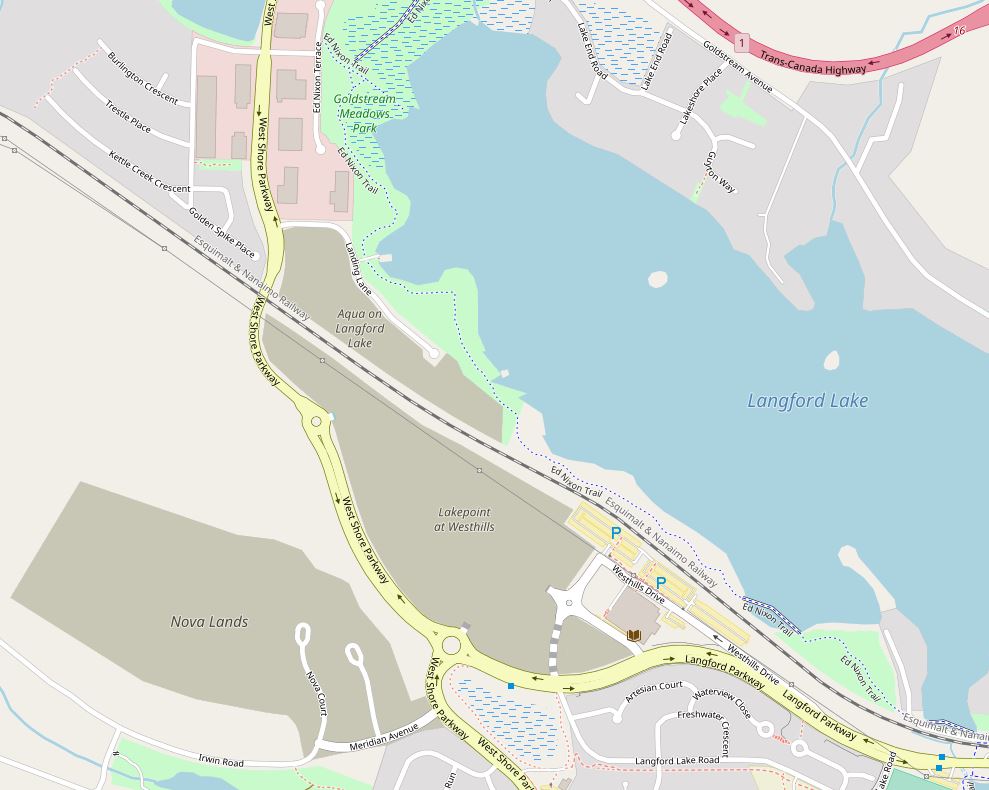
EDIT:  Looks like OSM has it:


https://www.openstre....4494/-123.5366

Attached Images

  • Capture.JPG

Victoria current weather by neighbourhood: Victoria school-based weather station network

Victoria webcams: Big Wave Dave Webcams


#74 sdwright.vic

sdwright.vic

    Colwood

  • Member
  • 6,685 posts

Posted 15 October 2017 - 07:56 AM

Your house may of changed, but roads very rarely do... except when new ones are built.

When you use your actual computer with Google Maps, the date of that screen shot is given to you. But for travel with you car, your new shed in the back yard isn't all that important.

Edited by sdwright.vic, 15 October 2017 - 07:56 AM.

Predictive text and a tiny keyboard are not my friends!

#75 Cassidy

Cassidy
  • Banned
  • 2,501 posts
  • LocationVictoria

Posted 15 October 2017 - 08:03 AM

the date of that screen shot is given to you. 

Those dates are not at all accurate as relates to when the photo was taken.


I too had long been under the impression that the dates on the bottom of the Google Maps screen reflected the day the Google camera car drove by and took the picture, but the street view date of my house is noted as 2017, and my dear mothers car hasn't been in the driveway since the she passed away 5 years ago.


  • Nparker likes this

#76 sdwright.vic

sdwright.vic

    Colwood

  • Member
  • 6,685 posts

Posted 15 October 2017 - 08:20 AM

Are you looking at Google Inc. Copyright date. Because I use this on my computer a lot for work, and it uses two dates. The Google copyright date and then another date of when the car drove through. It does help to know that two years ago you had a speed boat in your driveway.
Predictive text and a tiny keyboard are not my friends!

#77 Cassidy

Cassidy
  • Banned
  • 2,501 posts
  • LocationVictoria

Posted 15 October 2017 - 08:47 AM

I look a them both, and sometimes the two dates are the same (and both wrong), and sometimes the two dates are different (with one of them definitely accurate).


There doesn't seem to be any sort of consistency as to when they're correct, and when they seem to be out of whack.


But you're quite right in stating that they're very often correct ... just not always correct :)


  • sdwright.vic likes this

#78 kxl

kxl
  • Member
  • 206 posts

Posted 15 October 2017 - 08:55 AM

Apple Maps shows only a small section of the route and mislabeled it as “Langford Parkway”

#79 Mike K.

Mike K.
  • Administrator
  • 83,592 posts

Posted 15 October 2017 - 09:10 AM

Google traffic conditions are updated in real time because Google analyzes the GPS data of everybody who's currently using Google Maps while they're driving. Google analyzes GPS data and vets it against the speed you should be traveling at, the speed your were traveling at, and the speed you're currently travelling at.


Traffic conditions, yes, but road closures are directly communicated to various platforms (like Waze, which Google Maps integrates with).


Westshore Parkway has been displayed on OpenStreetMap since it opened, but neither Google nor Apple maps have added the road.


Know it all.
Citified.ca is Victoria's most comprehensive research resource for new-build homes and commercial spaces.


#80 kenmuir

kenmuir
  • Member
  • 84 posts

Posted 15 October 2017 - 07:11 PM

Well, I did see a Google maps camera vehicle parked at the Save-on-Foods across from Uptown at the end of August, so hopefully some updates will be coming soon.  I'm not aware if the street views and map data are connected though.


You're not quite at the end of this discussion topic!

Use the page links at the lower-left to go to the next page to read additional posts.


0 user(s) are reading this topic

0 members, 0 guests, 0 anonymous users