Here is the official description
The Gorge Waterway is from the Craigflower Bridge to the Selkirk Trestle which is in the Selkirk waters of the Upper Harbour
99% of people know this
https://www.crd.bc.c.../gorge-waterway
The Barge is in the Upper Harbour
Case Closed
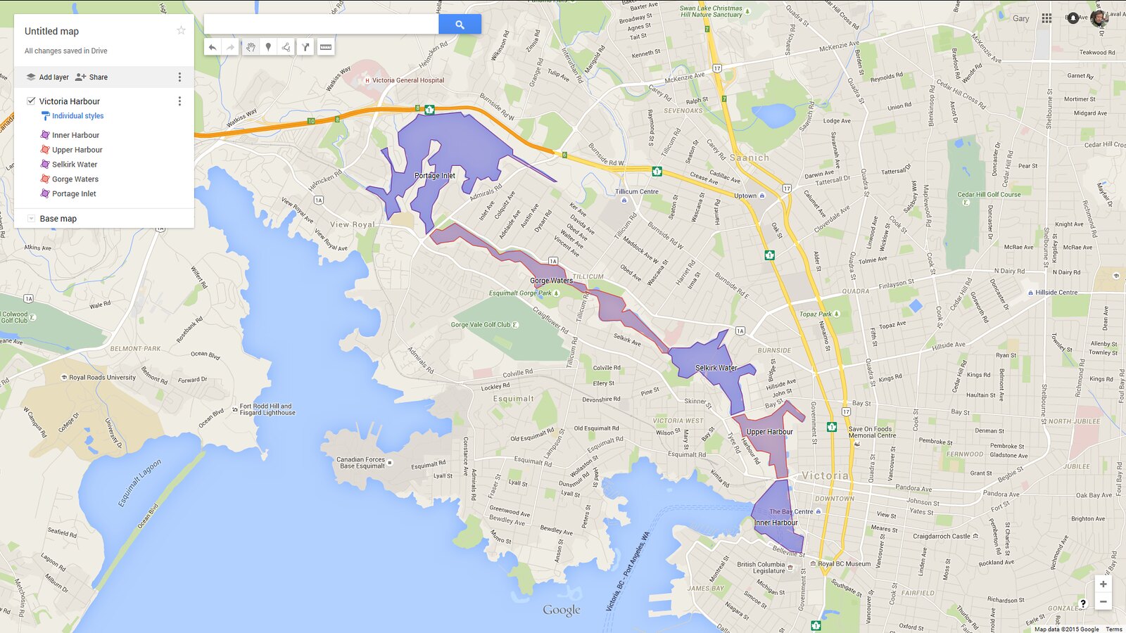
HB, while you are correct that the Seaspan barge is not in the Gorge Waters, it is also not in the Upper Harbour, it is in Selkirk Water. The Vancouver news media may have decided to use a more broad, although technically incorrect, description of the area the barge was in. If they had said Selkirk Water, I think most people would not have had a clue as to where that is. It also doesn't help that everyone's goto map, Google Maps, only lists TWO of the harbour's five sections regardless of zoom - Upper Harbour and Gorge Waters.
If we assume the government's GeoBC website is the definitive word on the subject, here are the five sections of Victoria Harbour with a map I made outlining the sections with dual color labels for clarity. BTW, they use Chapman Point as the start of the Gorge, not the Trestle Bridge as the CRD does. Do locals even know where Chapman Point is? Again, Google Maps is no help so certainly the Trestle Bridge is an easier landmark. As a relative newcomer to Victoria I've always been confused about the various harbour sections and where they begin/end and so this discussion has been educational. 
http://apps.gov.bc.c...es/25709.html
Victoria Harbour is comprised of Inner Harbour, Upper Harbour, Selkirk Water, Gorge Waters and Portage Inlet. The Inner Harbour is entered between Shoal Point & Colville Island and extends northeast to the Johnson Street Bridge; the Upper Harbour extends north from the Johnson Street Bridge to Point Ellis Bridge; Selkirk Water extends northwest from Point Ellis Bridge to Chapman Point; Gorge Waters extends northwest from Chapman Point to Maple Point/Craigflower Bridge; Portage Inlet extends north of Craigflower Bridge.