More for the Lightbulb thread I suppose, but some of those LED DRLs are also quite irritating. Maybe I'm just getting grumpy.
It's probably both.


Posted 19 September 2019 - 06:43 PM
More for the Lightbulb thread I suppose, but some of those LED DRLs are also quite irritating. Maybe I'm just getting grumpy.
It's probably both.

Posted 19 September 2019 - 07:29 PM
The problem then becomes remembering to turn them off when you park, if it's daylight enough that you don't otherwise notice. Flat batteries are no fun.
In my vehicles they automatically shut off after 10 seconds or so.

Posted 16 November 2019 - 09:03 AM
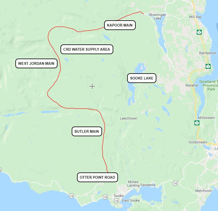
The Friends of the Sooke Hills recently thought they had cracked the code and discovered the Malahat alternative that the NDP wants to build and have available for times when the Malahat is closed.
There were photos posted to the group's Facebook page of what they called a new route via West Jordan Main, which heads west from the northern tip of Shawnigan Lake then a ways later straight south (mostly) and connects with Otter Point Road in Sooke via a logging main in that area.
The map they created depicts where new work had recently been done on West Jordan, and they considered that to be a sign of a new public roadway. On the surface you can't blame them, as any road improvements done to major logging mains in our region while we await for the NDP's announcement are fodder for speculation. I've speculated on a new route myself in the past (you'll find it up in this thread somewhere).
I'd just like to say that if you hear of the West Jordan Main theory as being the second route, keep in mind that that likelihood is low given the distances involved and the fact that the road passes through precarious territory that you wouldn't want to be sending hundreds of people down who don't have experience driving those roads. Any improvements that were made to West Jordan are for the benefit of logging operations.
Know it all.
Citified.ca is Victoria's most comprehensive research resource for new-build homes and commercial spaces.

Posted 16 November 2019 - 11:36 PM
Added the map image. IF valid, that's quite the detour, and forces a large volume of traffic down Sooke Road. Then of course there's an accident on Sooke Rd and everyone in the area is stuck. The Facebook post reads to me like a case of making connections between disparate happenings and projecting a sneaky new alternate route in the works.
Edited by grantpalin, 16 November 2019 - 11:37 PM.
Posted 17 November 2019 - 06:09 AM
Know it all.
Citified.ca is Victoria's most comprehensive research resource for new-build homes and commercial spaces.
Posted 17 November 2019 - 11:34 AM
Know it all.
Citified.ca is Victoria's most comprehensive research resource for new-build homes and commercial spaces.
Senior Case Officer
Posted 17 November 2019 - 12:58 PM
Posted 17 November 2019 - 05:39 PM
Know it all.
Citified.ca is Victoria's most comprehensive research resource for new-build homes and commercial spaces.

Posted 29 November 2019 - 10:10 AM
The last time the Malahat was closed for a rock slide or a downed tree is quite a while compared to how frequent vehicles are the cause of a closure. We all recognize that vehicle related closures are most commonly a result of carelessness, be it speed, distracted driving or other. I personally believe that the cause of most crashes on the Malahat are speed related. So here is my suggested solution before we tear up the watershed to build a second route.
1.Take the camera apparati that used to be at either end of the Port Mann or Golden Ears Bridges and install one set at each end of the Malahat.
2.Based on the legal and recommended speed limit for the Malahat, calibrate the camera set up to a specific amount of time it should take a responsible driver of either a car, truck or rig to drive the route either way.
3.When a vehicle enters the Malahat the camera snaps a photo; another snaps a photo as the vehicle exits the Malahat. If the vehicle exits the Malahat sooner than it should within in acceptable time limit, a costly ticket + points is issued to that driver.

Posted 29 November 2019 - 10:31 AM
1.Take the camera apparati that used to be at either end of the Port Mann or Golden Ears Bridges and install one set at each end of the Malahat.
2.Based on the legal and recommended speed limit for the Malahat, calibrate the camera set up to a specific amount of time it should take a responsible driver of either a car, truck or rig to drive the route either way.
3.When a vehicle enters the Malahat the camera snaps a photo; another snaps a photo as the vehicle exits the Malahat. If the vehicle exits the Malahat sooner than it should within in acceptable time limit, a costly ticket + points is issued to that driver.
Didn't they try to introduce this recently? The outrage from those who oppose camera-based fines of all types was furious.
Lake Side Buoy - LEGO Nut - History Nerd - James Bay resident

Posted 29 November 2019 - 10:39 AM
Didn't they try to introduce this recently? The outrage from those who oppose camera-based fines of all types was furious.
Some red light cameras at intersections have been upgraded to also measure speed through the intersection. Most of them are on the mainland.
Re: speed cameras on corridors, I believe that China uses this method on some highways.

Posted 29 November 2019 - 10:43 AM
The last time the Malahat was closed for a rock slide or a downed tree is quite a while compared to how frequent vehicles are the cause of a closure. We all recognize that vehicle related closures are most commonly a result of carelessness, be it speed, distracted driving or other. I personally believe that the cause of most crashes on the Malahat are speed related. So here is my suggested solution before we tear up the watershed to build a second route.
1.Take the camera apparati that used to be at either end of the Port Mann or Golden Ears Bridges and install one set at each end of the Malahat.
2.Based on the legal and recommended speed limit for the Malahat, calibrate the camera set up to a specific amount of time it should take a responsible driver of either a car, truck or rig to drive the route either way.
3.When a vehicle enters the Malahat the camera snaps a photo; another snaps a photo as the vehicle exits the Malahat. If the vehicle exits the Malahat sooner than it should within in acceptable time limit, a costly ticket + points is issued to that driver.
Far too much "Big Brother" for my liking. I have been told by a number of first responders that the majority of the accidents on the Malahat come from poor/distracted drivers. Speeding is the go to/hot button that outrages the public and thus it garners the most publicity. Enforce the smaller details, lane changes, signaling , tailgating, improper tires etc. etc. and I would wager there would be a marked decline.

Posted 29 November 2019 - 11:13 AM
The last time the Malahat was closed for a rock slide or a downed tree is quite a while compared to how frequent vehicles are the cause of a closure. We all recognize that vehicle related closures are most commonly a result of carelessness, be it speed, distracted driving or other. I personally believe that the cause of most crashes on the Malahat are speed related. So here is my suggested solution before we tear up the watershed to build a second route.
1.Take the camera apparati that used to be at either end of the Port Mann or Golden Ears Bridges and install one set at each end of the Malahat.
2.Based on the legal and recommended speed limit for the Malahat, calibrate the camera set up to a specific amount of time it should take a responsible driver of either a car, truck or rig to drive the route either way.
3.When a vehicle enters the Malahat the camera snaps a photo; another snaps a photo as the vehicle exits the Malahat. If the vehicle exits the Malahat sooner than it should within in acceptable time limit, a costly ticket + points is issued to that driver.
You'll be hard pressed to find a major incident that closed the Malahat being related to 'speeders'.
In the last 10-15 years the primary causes have been, DUI, drugs, driver error, mechanical, weather and poor vehicle conditions
The tanker that flipped in Goldstream was shown to have been drinking
The motor-biker that was killed by the women on drugs
Attempting to cross 4 lanes of traffic to enter a property
black ice on the one spot where the road upgrade wasnt showing adequate drainage
severe rainstorm and 4 bald tires and driver inexperience
Loss of brakes in the septic truck
etc etc
Not one of these would have been prevented by a camera and someone getting a ticket in the mail 2 months later. And yet its these incidents and others like them that are then used as an excuse to advocate for things like time/distance cameras etc that will only generate cash flow and effectively criminalise most of the travelling public and not reduce the risk.
Alberta has just come out with a mandate that says Munis cant buy any more speed cameras unless they can prove they actually reduce traffic collisions and injuries https://www.cbc.ca/n...pment-1.5374087
The government will begin a two-year consultation process with police services and municipalities to ensure photo radar is used to improve safety and is "not just a hidden tax,"
I dont advocate for aggressive drivers and they deserve to have the book thrown at them, but there is a difference between the 85th percentile that travel 95-100 in an 80 zone and the .1% that exceed 120 in that same road
Highways are far safer to travel on than urban streets
Edited by rjag, 29 November 2019 - 11:14 AM.
Posted 29 November 2019 - 11:16 AM
Far too much "Big Brother" for my liking. I have been told by a number of first responders that the majority of the accidents on the Malahat come from poor/distracted drivers. Speeding is the go to/hot button that outrages the public and thus it garners the most publicity. Enforce the smaller details, lane changes, signaling , tailgating, improper tires etc. etc. and I would wager there would be a marked decline.
Very costly to police all of the smaller details. I imagine the cost of policing all those details would be a costly venture. The province already owns $150 million worth of bridge cameras.
Resident Housekeeper

Posted 29 November 2019 - 12:47 PM
Very costly to police all of the smaller details. I imagine the cost of policing all those details would be a costly venture. The province already owns $150 million worth of bridge cameras.
You realize moving around a few 'highway cams' aren't even close to what's required to run time/interval/speed enforcement?
And aren't we constantly being told 'we need to save lives at all cost'? If so, perhaps we should police the smaller details. It's the lack of overall care and precision on our roads that's causing the mayhem.
Posted 29 November 2019 - 02:22 PM
Very costly to police all of the smaller details. I imagine the cost of policing all those details would be a costly venture. The province already owns $150 million worth of bridge cameras.
Not really the point. They are 'playing politics" when it comes to cameras and taking the easy way out. Would you care about the cost if it saved a loved ones life - or should it all be about how much we can save by using the camera's we already have (while looking fiscally responsible by doing it.)?

Posted 30 November 2019 - 01:47 PM
1.Take the camera apparati that used to be at either end of the Port Mann or Golden Ears Bridges and install one set at each end of the Malahat.2.Based on the legal and recommended speed limit for the Malahat, calibrate the camera set up to a specific amount of time it should take a responsible driver of either a car, truck or rig to drive the route either way.
3.When a vehicle enters the Malahat the camera snaps a photo; another snaps a photo as the vehicle exits the Malahat. If the vehicle exits the Malahat sooner than it should within in acceptable time limit, a costly ticket + points is issued to that driver.
Only works for (as in, against) drivers who go in one end of the Malahat and out the other. Those who live/work along the highway or in Shawngan Lake could bomb along as fast as they want because in a typical trip they're going to interact with the cameras in reverse order: "exit" followed however long later by "enter".
Old White Man On A Canadian Island

Posted 30 November 2019 - 02:33 PM
Posted 30 November 2019 - 03:57 PM
Know it all.
Citified.ca is Victoria's most comprehensive research resource for new-build homes and commercial spaces.
Old White Man On A Canadian Island
Posted 30 November 2019 - 03:59 PM
And no, running a road way west of the Malahat isn’t a reasonable solution.
that's ridiculous for sure.
coquihalla
inland island highway
sea-to-sky improvements
south fraser perimeter
a good premier can get it done.
Edited by Victoria Watcher, 30 November 2019 - 04:02 PM.


0 members, 2 guests, 0 anonymous users

Community Forum Software by IP.Board 3.4.6
Licensed to: Citified Media Inc. All materials © Copyright Citified Media Inc. All rights reserved.
